This article is over 5 years old and may contain outdated information.

People & Culture

Why the North Pole matters: An important history of challenges and global fascination

In this essay, noted geologist and geophysicist Fred Roots explores the significance of the symbolic point at the top of the world. He submitted it to Canadian Geographic just before his death in October 2016 at age 93.

  • Published Mar 14, 2017
  • Updated Sep 01, 2022
  • 5,167 words
  • 21 minutes
Heinrich Scherer's 1702 chart of the North Pole Expand Image
Advertisement

The North Pole is world news again.

There was a flurry of publicity in 2007 when a Russian submarine placed a metal flag on the seabed at latitude 90 degrees north. No claim was made, and the event had no geographical significance or political impact, but it demonstrated Russian technology and capability in the Arctic Ocean.

It wasn’t until December 2014 that Denmark claimed the North Pole and surrounding area under the rules of the United Nations Convention on the Law of the Sea (to which all northern nations are signatories), with Russia following suit in August 2015 and Canada later announcing plans to submit its own Arctic continental shelf claim, including the pole, by 2018. This raises historical, political and scientific questions about the North Pole itself. What is it, where exactly is it, and why is it such an object of interest?

Displaying a flag at the North Pole has been a well-known international game for about a century. On the ice-covered surface of the ocean, as close to 90 degrees north as navigation systems could determine, flags of many nations — United States, U.S.S.R./Russia, United Kingdom, Canada, Norway and France at least have been unfurled, not to mention the personal flags carried there by passengers from many nationalities on Russian tourist trips. Flags have been carried there by ships, aircraft, submarines, skidoos, dog teams, and cross-ocean skiers. From the air, Norwegian, Italian, and Soviet flags have been dropped over the pole, almost as a rite of passage. And the flag planted on the sea bed by the deputy speaker of the Russian Parliament is the second Russian flag in or near that location; the first was placed there 40 years ago, together with flags of all member states of the United Nations and of the United Nations Organization itself, by a Canadian scientific party, demonstrating that the North Pole belonged to no single nation but that the information from that spot was the property of all humankind.

However, the importance of the North Pole, the challenge it represents, and the fascination it has for governments, for science, and for adventurous personalities, has a much longer history and larger importance.

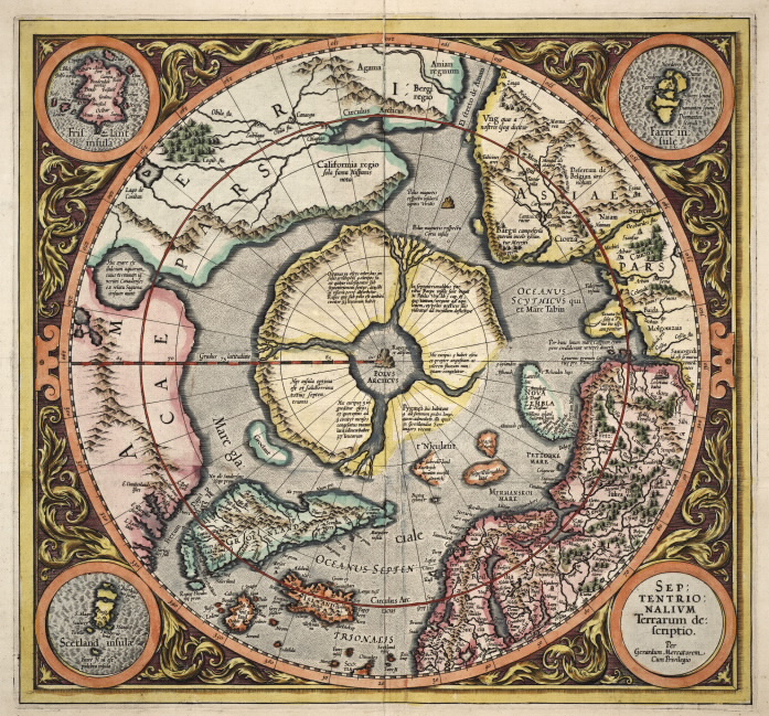
In a crude way, the North Pole is easy to define. It is simply the north end of the axis around which our planet turns in its daily rotation. The axis emerges from the solid earth on the lower flank of the long undersea mountain range known as the Lomonosov Ridge, at a depth of 4,621 metres below present sea level. The sea ice above it is generally tightly packed, but broken and jumbled and sometimes with large cracks or patches of open water, and moves erratically, usually in the general direction of the west side of the Atlantic Ocean, at about a kilometre a day (although one time when we were camped there a three-day storm moved us about 40 kilometres).

This axis wobbles a bit, rather like an unbalanced wheel with a faulty bearing, so that the precise North Pole is fleeting or meaningless. The North Pole itself is not a place; it has no lateral dimension; but as a mathematical or observational construct it is essential for map-makers and modellers and has been a powerful symbol in philosophy and the public mind for centuries.

Egyptian, Arab, and Greek star-gazers had noted as early as 3000 BC that the heavens revolved around a single point, close to a star in the constellation now known by the Latin name Ursa Minor (Little Bear). That star is in his tail (for some reason, celestial bears have long tails while earthly bears do not). The Greeks named this star Polaris, marking the pivot or axis, directly under which there must be a North Pole (pivot point) on the Earth, and by extension a South Pole on the opposite side of the globe. They divided the Earth into degrees of latitude, and thus the North Pole was exactly 90 degrees North, at right angles to the plane of the Equator. Greek and Roman astronomers and poets incorporated the concept into their literature.

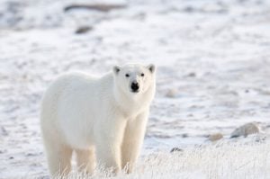
When the first recorded Arctic navigator, Pytheas, about 320 BC voyaged north past the coasts of France and Britain and on until he encountered what must have been sea ice, he reported that the pole star was very high overhead, and that huge white bears roamed on the sea, confirming the speculations that the regions under Polaris were guarded by the celestial bears Arctos, and it has been known as the Arctic ever since.

The first description of the North Pole itself, of which we have evidence today, is in a book attributed to Nicholas of Linne, a scholar of Oxford, entitled De Inventione Fortunata and subtitled qui liber incipit a gradua 54 usque ad polum (“which book begins at latitude 54 degrees and goes as far as the pole”). No copies are known today, but the book was widely quoted, and shows that by the 14th century, degrees of latitude were already in use for geographical description and that the North Pole was a widely understood concept. For the next several centuries, this book was the North Pole reference for geographers and cartographers.

Johannes Ruysch of the Netherlands made one of the first maps of the North Pole region. On his 1507 map, which was included as Plate 1 in the 1506 edition of the authoritative text Ptolemy’s Geography, he cites his source: “In the book De Inventione Fortunata it may be read that at the North Pole there is a high mountain of magnetic stone 33 German miles in circumference. This is surrounded by mare sugunum which pours out water like a vessel through openings below. Around it are four islands, surrounded by extensive desolate mountains for 24 days’ journey, where there is no human habitation.”

It is speculated today that Nicholas of Linne probably assembled his information from Norse seafaring stories and myths, and made a logical attempt to explain the mysterious force that attracted the magnetic lodestone, or compass, which was at that time coming into use. It was also apparently an attempt to explain what happens to the water of the Atlantic Ocean which flows in a northerly direction past the coasts of Europe.

Later map-makers, such as Mercator, who produced world charts which they continually up-dated as new discoveries were made, retained the four islands and the central mountain of De Inventions Fortunate at the North Pole up until the 17th century.

Where exactly is the North Pole?

Despite the philosophical and scientific success of the First International Polar Year, the international steeplechase to the North Pole continued.

In 1909, after several futile attempts, Robert Peary of the United States Navy reached what he determined to be Latitude 90 degrees north — the North Pole. To be sure of his position, Peary travelled some distance beyond his calculated spot, and also a number of miles at right angles to his approach route, to take supplementary readings of the altitude of the sun.

Many scholars and analysts have examined Peary’s field notes and calculations, and have detected what seem to be errors and discrepancies, but the general conclusion is that, as an experienced naval officer with a high standard of integrity despite his over-riding personal ambition, Peary did reach 90 degrees north as accurately as his instruments and the navigation tables of the time could determine.

Modem analysts have expressed the opinion that, given the equipment he had, at the time of his last observation Peary was probably within a kilometre of the pole as it was at that moment. If indeed his notebooks contain his actual readings and not later back-calculations, Peary can be given credit for the first attainment of the long-sought-after goal.

But where exactly was, or is, the centre of rotation?

The analyses of Peary’s and other more sophisticated determinations of high-latitude positions reveal some sources of error and uncertainty in attempting to locate the axis of our spinning planet. These can include variations in the refraction of light from the sun or stars to an observer on the surface; the fact that the sea ice upon which the instruments are mounted is changing position or rotating while the observations are being made; that the sea and its cover of ice are “tilted” by ocean currents and wind, so that the horizon is not exactly perpendicular to the pull of gravity; and that the “vertical” direction of gravity may not be parallel to the axis of rotation because of asymmetry of the geological structure of the underlying rock. To add to these problems, the navigation tables available to Peary and until 40 years ago and used to calculate the trajectory of the sun were based on observations made at lower latitudes and extrapolated to highest latitudes on the assumption that the sea-level shape of the Earth was a sphere. Also, because of the “polar wobble” the precise pole is hard to catch. Lutke’s mathematical line upon which to raise the flag seems to be dancing.

None of these problems were of concern to Admiral Peary or to most of the several parties that have reached the pole — close enough for their purposes — in the following century. But for those who are responsible for precision of navigation at high latitudes, or for exact description of the behaviour of the planet, they become important.

With the advent of polar-orbiting satellites and long-range rockets during IPY-III, and the consequent military development in the United States and U.S.S.R. of Intercontinental Ballistic Missiles whose tracks crossed the Arctic region at high latitudes, it became important to know quite precisely the shape of the planet and the distribution of the pull of gravity in the region of the North Pole. Geodesists and astronomers had already calculated a mathematical figure for the planet, known as the geoid, and had determined that the Earth was a slightly flattened sphere with its polar dimension some 40 kilometres less than the average equatorial diameter (12,720 kilometres vs. 12,760 kilometres). The expected orbits of the satellites and the potential tracks of missiles were calculated with respect to the geoid.

For a single pass of a satellite, the uncertainty in the geoid calculation was insignificant. But with repeated passes, errors accumulated and became important. As the tracks of the satellites and rockets are determined by the Earth’s gravity field under their path, it became important to know accurately the shape of the geoid and the variations in gravity at highest latitudes.

The obvious way to check the apparent errors in satellite tracks was to compare observations of the passes of the satellites with the apparent movements of the stars, which showed how the planet, together with its atmosphere and its gravity field, was moving in space in its orbit around the sun, carrying the orbiting satellites with it. The Canadian Polar Continental Shelf Project, of which I was director at the time, undertook a study of this problem.

The discrepancies between the observations of satellite passes and their calculated orbits could only be measured directly by instruments located as close as possible to the pole, where the stars remain at nearly constant angle above the horizon as the Earth rotates, so that unknown errors due to refraction by light taking different paths through the atmospheric layers would be minimized. Thus, very careful prolonged observation at the highest possible latitude was necessary.

In 1967, we carried out a geodetic/geophysical/hydrographic reconnaissance in the vicinity of the North Pole to ascertain whether it would be feasible to take readings with the required accuracy of the stars and passing satellites from stations on the drifting sea ice, to measure the tilt of the sea ice horizon, and to relate these measurements to the movement of the instruments on the ice as determined from sonar signals from a fixed location on the sea floor. The reconnaissance was successful. The party spent nearly two weeks camping and setting up instruments between 89 and 90 degrees north, serviced by a single-engine Otter aircraft which also carried out hydrographic and gravity measurements that gave a profile of the sea floor and information on the geological structures between the North Pole and the nearest land, Greenland and Ellesmere Island, about 850 kilometres away.

For the fixed location on the sea floor we had built a battery-powered sonar transponder that could be activated by a sound signal from the surface at a given frequency, and which would then send a coded signal back to the surface. The time interval between the outgoing and received signals, corrected for the speed of sound in the different layers of water gave a measurement of the distance between the sea-floor transponder and the instrument on the ice surface. We were thus able to track the movements of instruments on the sea ice quite accurately.

The transponder was a tube 15 centimetres in diameter and a metre and a half long. We called it, naturally, “The North Pole,” so we painted that name on it. Just for fun, and because we were all convinced of the international value of our work, we applied below the name the flag of the United Nations the flags of all the circumpolar countries including of course the U.S.S.R., and then the flags of all the member states of the United Nations. These flags were sticky-paper prints from a school geography exercise book, designed for students to peel off and stick on descriptions of respective countries. We applied the flags in alphabetical order on the transponder, then sealed the whole instrument with fibreglass resin.

As I wrote to my superior at the time, the North Pole, a point without dimensions, belongs to no country, and we hoped our work would be useful to all humankind.

The transponder worked well. We now had a real pole at the North Pole. Weyprecht would have been pleased: the geographical pole was being used for observing phenomena of planetary behaviour.

Thus it came about that a Canadian party of scientists spontaneously placed the flags of the United Nations on the sea bed at the North Pole, 40 years before Russia noisily planted a second Russian flag for political reasons. Soviet scientists at the time, of course, knew all about our activity. None of our work was secret or classified. And a couple of years later the director of the U.S.S.R. Arctic and Antarctic Research Institute congratulated us on a fine piece of work.

The quest for the Pole

Claims to the North Pole have a long history. In 1578, Queen Elizabeth I of England asked the scholar John Dee to produce an argument for her rights to the northern lands that Martin Frobisher had visited in 1576-78 and claimed in her name. The queen herself had named the newly discovered lands Meta Incognita (Unknown Boundaries), and that name is still the official designation for that part of Baffin Island. Dee was a remarkable polymath, tutor to the royal court, instructor in navigation to Frobisher and to many other explorers at that time, and a prodigious collector of books which can with some justification be said to have led to the concept of the British Library.

The result of the Queen’s request was a remarkable document, with a large map, still held in the British Library. It cites in some detail the grounds for sovereignty by the British monarchy over much of the undiscovered modem world, including “Groenland and all northern isles compassing … even until the North Pole.” This document undoubtedly had an influence in spurring and maintaining an interest in Britain in polar exploration.

During the 17th and 18th centuries, most explorations focused on geographic discoveries of new lands and trade routes between Europe and China or the Spice Islands (the Indonesian Maluku Islands). But to some, to reach physically the poles of the Earth came to represent an ultimate challenge. The very inaccessibility of the North Pole increased the challenge. To stand at the exact centre of rotation was seen to be a triumph of human determination, and a demonstration that “Man” was able to conquer all physical obstacles and to rule the Earth.

More specifically, the challenge became a question of the superiority of one nation over another. To reach the highest latitude became a national ambition and a goal in itself. In 1742, the British Parliament offered a substantial prize for the first ship to transit the Northwest Passage (a prize that was not won for over a century), and later there were also prizes for “farthest north.” These prizes not only provided monetary incentives to aspiring explorers and sea captains, but they legitimized government backing of national rivalries to reach the pole.

Other philosophies were also emerging, however, largely as a result of the advance of science. In 1773, the Royal Society of London sponsored the first truly multidisciplinary scientific expedition anywhere: “A voyage towards the North-Pole to be of service to the promotion of natural knowledge,” commanded by Constantine Phipps. Although the expedition did not discover new land (that was not its purpose), it returned with a wealth of information on the temperature, depth, salinity of the Atlantic portion of the Arctic Ocean, careful descriptions and classifications of fishes, birds, sea mammals (they even collected a whale foetus), polar bears (which still carry the scientific name thalarctos maritimus Phipps), information on the aurora, patterns of magnetism and gravity measurements taken on Spitzbergen which improved calculations of the shape of the planet.

This expedition added tremendously to knowledge of the Arctic and set the pattern for scientific studies in the next century, but has been almost completely ignored by geographers and historians who were, and in the popular mind still are, bemused by new geographic discoveries and the challenge to be first at the pole. The only item from this very fruitful expedition which received wide attention was a trivial incident in which 15-year-old midshipman Horatio Nelson without permission went out on the ice to try to shoot a polar bear, was called back by a cannon shot from the ship, and was severely reprimanded by the captain.

In several countries in Europe and in the United States, a different mindset developed between the geographical societies, for whom exploration of new territories and reaching the poles was a national honour and duty, and the academies and royal societies, who focused on increasing knowledge of natural phenomena. That distinction has lasted almost two centuries, and has influenced both the science and the history of the polar regions.

A telling example of the difference in perspective between the “scientific” and the “adventure-driven” approach to North Pole exploration is a letter sent by Feodor Lutke, one of the great Russian arctic explorers who in 1824-40 had mapped Novaya Zemlya and much of the Siberian coastline. He was well known in scientific circles in Europe, and in 1865 wrote to the president of the Royal Geographic Society of London, which at the time was seeking government and public support for another expedition to the North Pole:

“Too much prominence [is] given to the hope or desire of reaching the pole, a thing that I consider of no importance compared to the great goal of exploring all of the Arctic region, where the pole — an abstract, mathematical point that doesn’t even exist in reality — plays no part. The idea of placing the national flag there may smile on national self-respect; but one must not forget that to do this one would have to use a mathematical line as a flag­pole.”

It is ironic that this clearly stated comment on “North Pole fever” compared to the need for Arctic science should have come from an experienced Russian explorer, while much of the present-day fever seems to have been started by Russian actions.

In 1874, Karl Weyprecht of Austria returned from his second expedition, where he had investigated the relationship between the aurora and the fluctuations of magnetic activity, and incidentally had discovered Franz Josef Land (hence the Austrian name for the most northerly archipelago north of Asia). He became convinced that scientific study should take precedence over geographic exploration.

He undertook a campaign aimed at the scientific authorities: “Past arctic explorations have been adventurous and of little value. They constitute an international steeplechase to the North Pole. Immense sums have been spent and much hardship endured for the mere purpose of topographic and geographic observation, while strictly scientific investigations have been given secondary status. The ultimate aim must lie higher than the sketching and naming in different languages of islands, bays and promontories buried in ice.”

Weyprecht proposed a new set of goals for polar exploration, based on the objective of cooperative contribution to natural science rather than competition for primacy of discovery. His ideas were considered radical, unpatriotic and even heretical, and at first were strongly opposed by the scientific establishment. But his logic gradually won over the leading scientists and academies in Europe and the United States. An International Polar Commission was formed to plan a coordinated program of studies.

Weyprecht drew up a number of principles, including that the Earth should be studied as a planet with all parts connected, that geographic discovery is of importance according to the degree to which it extends the field of scientific investigation and that the geographic pole has no greater significance for science than any other point in high latitude — unless for observing phenomena of planetary behaviour.

The outcome, after a great deal of planning, was the International Polar Year, which has become a major influence in the course of science over the last 130-plus years. For the First International Polar Year (1882-83), fifteen expeditions, sponsored by 11 countries, went to Arctic and sub-Antarctic locations and carried out a very rigorous 13-month program of simultaneous observations in a wide range of science subjects. Fourteen subsidiary stations were set up in settlements in sub-polar latitudes and 18 already established observatories throughout the world cooperated by taking comparable observations on the same schedule. The IPY was thus the first coordinated study of the entire planet.

In addition to the wealth of scientific information obtained, the international cooperation and coordination that was essential for IPY-I had a profound effect on the conduct and support of science in many disciplines throughout the world. Fifty years later, IPY-I was followed by IPY-II (1932-33), in which 44 countries took part; and 25 years after that by IPY-III, also known as the International Geophysical Year 1957-58, involving 63 countries and 6,000 scientists. Twenty-five years later still we have had IPY-IV (2007-08), the largest coordinated multidisciplinary scientific activity ever, with institutions from 67 countries and 10,000 scientists working on 220 projects with an international secretariat.

The consequences of the International Polar Years have been important far beyond the polar regions and their rigorous scientific programs. The first IPY led to the widespread practice of peer review to maintain the quality of published science, and it and later ones led to international coordination of observation methodologies, standardized calibration of instruments, global networks for study of planetary phenomena and acceptance of national responsibility to contribute to knowledge beyond national borders. The first Sputnik, or global orbiting satellite, was an IPY endeavour, and the Antarctic Treaty, through which 46 nations agree to manage one-sixth of the planet by consensus, is a direct outgrowth of IPY-Ill. None of the activities, however, have directly involved the North Pole, although observations at the South Pole are important in IPY-III and IPY-IV.

Advertisement

“On planet Earth, one cannot throw anything away. Even if you drop something in mid-ocean at the North Pole, it will turn up somewhere.”

Finding the North Pole

After a full year of calculations and testing of new equipment, we went back to the North Pole in 1969. We had a larger party and a lot of sophisticated equipment, serviced by Twin Otter and Bristol Freighter aircraft. We established a camp on April 2 on a big ice floe which at that time was about 18 kilometres “upstream” from the pole, hoping that during the course of our work it might drift close to the pole itself.

Observations started right away and continued until 3 May. Our ingenious geophysicist built a 200-metre long seawater-and-antifreeze level “instrument” that was patterned after the super-accurate techniques developed by the ancient Egyptians in constructing their pyramids. We made a large snow igloo, guaranteed non-metallic, to house the magnetic instruments. A transponder, larger and more powerful than the first, was dropped through the ice within a few hundred metres of the centre of planetary rotation according to our on-the-spot calculations, and we hoped that it went nearly straight down to the sea bed more than 4½ kilometres below. A few days later, about 12 kilometres away on the surface, we dropped a second one, thus improving the accuracy with which we could track our movement. Work on five separate but coordinated projects went on around the clock.

There were some interesting diversions during our month in residence at the North Pole. Persons originally from five countries were in the party, so we laid out a ski race course on the sea ice and held the “First International North Pole Ski Race.” The course was not exactly centred over the North Pole, but with the vagaries of ice drift it came close to it. As it covered most degrees of longitude and the International Date Line, depending on which way around the course one went, one could finish the day before or the day after one started. The pilots who flew the short hop-and-land gravity surveys had fun making out flight plans showing that they landed hours before or hours after they took off for a 10-kilometre flight. The artist Maurice Haycock produced some truly memorable paintings of North Pole scenery, some of which are now in galleries and institutes in different parts of the country. Toward the end of our stay there, I asked our Inuk technician how he felt being the first northern Indigenous person to work at the North Pole. He simply said, “No foxes. No women. Sun gone crazy.”

After the second transponder was lowered and its signal confirmed, we had a bit of a celebration. A half-used bottle of whisky was finished, and each of us rummaged through our pockets for a souvenir or message to put in the bottle and drop down the hole. We collected a couple of used tickets to the bar at Resolute, Maurice Haycock drew a little cartoon of six figures dancing around the pole and one fellow had an expired B.C. driver’s license. We stuffed it all in the bottle, put in the cork firmly, and shoved it down the hole in the three-metre-thick ice.

That was April 1969. The incident was pretty well forgotten, until in the spring of 1972 the mother of one of our pole party received at her Vancouver home a telephone call from a newspaper reporter asking whether she knew such-and-such a person. She replied that of course she knew him — he was her son — but he was working in the Arctic.

She was told that a newspaper agency in Iceland had her son’s driving license. She was alarmed at first, but there was no need for worry. A lady walking along the beach in northeast Iceland — a very sparsely inhabited bit of coastline — came across a bottle with some papers Inside. Most of them were indecipherable, but one printed was a driver’s license for someone with a Vancouver address. The finder brought her discovery to the attention of a newspaper agency in Iceland, which in turn referred it to an international newspaper agency which referred it ultimately to Vancouver and to a reporter who called the driver’s address. We were all intrigued that the bottle had turned up. But by what route had it taken from the North Pole to northeast Iceland? How long did it take? There was no information about how long the bottle may have been lying on the beach in Iceland.

Oceanographers have speculated about the bottle’s route and speed of travel. The one fact, as someone said, is that it is “demonstration that on planet Earth, one cannot throw anything away. Even if you drop something in mid-ocean at the North Pole, it will turn up somewhere.”

The careful measurements of satellite tracks, apparent movements of the stars, and the gravity surveys from this work enabled geophysicists and geodesists to calculate needed improvements in the mathematical shape of the planet in the region of the pole and in the gravity field that would influence satellites. Calculations of satellite trajectories were corrected and navigation tables were updated, and the data was entered into formulas for Global Positioning Systems, which at that time were just being developed. Information on the ocean “tilt” could be related to distant storms and wind patterns to give an idea of the drag of an ice pack on ocean currents. The eccentric motion of the axis of rotation, the polar wobble, was noted over a few weeks, providing material for new speculation on the influence of geological, oceanic and possibly even major atmospheric events on the planetary balance.

It has not been announced in the West what positioning system the Russians use for navigation of their under-ice submarines; but it seems likely that they employ the modern universal formulae for the geoid and gravity field for northern high latitudes and the region surrounding the North Pole.

If so, their confidence that they planted their flag accurately at the North Pole in 2007 would be based at least in part on the measurements made by the Canadian party who were there 40 years ago and who placed the first Russian flag (along with flags of other UN countries) nearby. The same information today provides the basis for defining the boundaries of areas once again in the news as claims are being prepared for jurisdiction over portions of the Arctic Ocean in anticipation that climate warming will change the environment and the accessibility of the whole Arctic region.

Anyone who today uses a GPS in northern areas or rides in an aircraft flying on a northern great circle route benefits from software that incorporates and is refined from readings taken through a big theodolite on the sea ice near the North Pole, observing the first generation of satellites as they passed under the constellations Ursa Major and Ursa Minor in 1967 and 1969. Truly, Arctos is still looking after us in the Arctic, and the star in the Little Bear’s tail is still important.

Advertisement

Are you passionate about Canadian geography?

You can support Canadian Geographic in 3 ways:

Related Content

People & Culture

The truth about polar bears

Depending on whom you ask, the North’s sentinel species is either on the edge of extinction or an environmental success story. An in-depth look at the complicated, contradictory and controversial science behind the sound bites

  • 4600 words
  • 19 minutes

People & Culture

On thin ice: Who “owns” the Arctic?

As the climate heats up, so do talks over land ownership in the Arctic. What does Canadian Arctic Sovereignty look like as the ice melts?

  • 4353 words
  • 18 minutes
Arctic Frontiers conference 2019

Environment

Five key takeaways from the Arctic Frontiers conference

The uncertainty and change that's currently disrupting the region dominated the annual meeting's agenda

  • 2651 words
  • 11 minutes

People & Culture

Kahkiihtwaam ee-pee-kiiweehtataahk: Bringing it back home again

The story of how a critically endangered Indigenous language can be saved

  • 6310 words
  • 26 minutes