Environment
Healthy rivers: Communities use DNA tool to keep tabs on freshwater quality
Many of Canada’s 25 watersheds are under threat from pollution, habitat degradation, water overuse and invasive species
- 996 words
- 4 minutes
This article is over 5 years old and may contain outdated information.
Environment
Streams surrounded by intact forest are better at providing clean water, carbon storage and wildlife habitat


Canada is a country covered by vast networks of water. Rivers, streams, lakes and wetlands span thousands of kilometres, connecting the different parts of our landscapes.
As water moves through these systems, it carries with it traces of the places it has been. These traces are not just swept up from river beds and lake bottoms as the water moves through; they also come from the landscape surrounding the waterways. When rain falls, it seeps slowly into the soil or around the rocks it lands on. Some of that water is then absorbed and used by vegetation, some of it may go toward recharging stocks of underground water, and some of it is likely to continue on toward nearby freshwater systems, carrying with it whatever it picks up along its route. This means that rain that lands in an agricultural field may carry traces of that field. Depending on how that field is managed, you would expect to find more or less fertilizer and pesticides, more or less sediments. In a different context, such as a landscape covered by forest, the rain that moves toward waterways would again carry different sediments, different traces.
In my PhD research, I sought to find out what happens to a stream when you protect the land surrounding it. Is the water found in such a stream different from the water found in a stream that is not surrounded by protected land?
I wanted to know how protection affects streams because most protected areas are not created specifically with streams in mind. Yet, protecting a stream and the land that surrounds it could have an important effect on that stream — and, subsequently, on the people and animals that interact with it. After all, streams are great places for recreation. In the area surrounding streams, called the riparian zone, we can go for peaceful walks or find delicious wild foods like elderberries, blueberries and Labrador tea. Riparian zones store carbon in vegetation and soil, preventing greenhouse gases from further heating the atmosphere. On top of all that, streams and their riparian zones provide habitat for numerous species that we care about.
When land isn’t protected, it tends to be converted to produce or extract resources, and I wanted to find out what would happen to our protected streams if they did undergo such changes. In Canada, some common ways we convert land include clearing forest for agriculture and harvesting timber. So, I sought to measure differences between streams surrounded by protected forest, unprotected forest, timber harvesting, and agriculture.
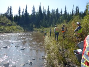
I figured the best way to answer my questions would be to visit several streams and collect data. Using a geographic information system — a computer tool that allows you to map, search and analyze data — I located 28 different but comparable streams that met my research criteria. All of the streams are located in Quebec, between two provincial parks, Mont-Tremblant and Monts-Valin. I spent a day or two at each of them, gathering information about what scientists call “ecosystem services,” which are essentially the different ways that humans benefit from nature. Specifically, I was interested in the provision of clean water, wild foods, carbon storage, recreational trails, habitat quality and biodiversity.
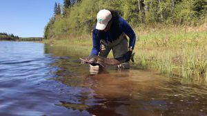
I collected water and insects, I counted the elderberry, blueberry, Labrador tea, raspberry and wintergreen plants that I saw, I identified and measured trees, and I looked for indicators of habitat that diverse species are able to live in. Then, I spent months in the laboratory analyzing these samples and months at the computer figuring out what they meant. I wanted to know what all this information could tell us about how protection and land use and cover affect the ecosystem services provided by streams and their riparian zones, as well as biodiversity.

It turns out that land use has a substantial effect on stream and riparian zone ecosystem services and biodiversity. Clean water provision, carbon storage, habitat quality, and tree diversity were significantly higher in and around streams surrounded by intact forest — protected or not. Surprisingly, recreational trails, wild foods, and aquatic biodiversity did not significantly differ between the four different watershed types I visited.
This tells us a few things. It tells us that protection matters for streams, but only because it is a way to prevent land use and cover from changing. Research shows us that when we don’t protect land, in the long run, we tend to change it, to develop it. So streams surrounded by unprotected forests, which are currently doing a better job at securing the provision of clean water, carbon storage, habitat quality and tree diversity than streams embedded in production landscapes, are always at risk of losing their ability to be strong providers of these services.
The data also tells us that streams that are surrounded by forestry and agriculture still provide numerous benefits and support biodiversity. Landscapes with agriculture and forestry do much more than just produce food and wood. By thinking of them in this way and paying attention to the diverse ecosystem services they rely on and support, we can make management decisions that maintain or improve their sustainability and multifunctionality.
Most importantly, this project shows that it is important to think carefully about the implications of land use management and protection around streams and their riparian zones. This is especially true in Canada, where we have such vast freshwater networks.
Now that this information is available, my hope is that people seeking to make decisions about land use management and protection will think about streams and their riparian zones. When they do develop land for agriculture or forestry, they will consider management approaches that sustain biodiversity and other ecosystem services.
I care about this subject because I love streams. I grew up playing in them and wish for future generations to be able to do so as well. They are the veins of our rivers and lakes, and keeping them healthy is as important to me as keeping myself healthy. Information is the key to making better decisions, and I hope that this information sheds light on a piece of the complex puzzle we must solve to foster more sustainable and equitable land management and protection decisions for freshwater ecosystems now and in the future.
Environment
Many of Canada’s 25 watersheds are under threat from pollution, habitat degradation, water overuse and invasive species
Wildlife
At least 50 species of fish can be found in the Arctic drainage basin in Ontario

People & Culture
The trauma of an entire generation without access to safe drinking water has left its mark

People & Culture
The Royal Canadian Geographical Society’s 2019 College of Fellows Annual Dinner was also a celebration of the organization’s achievements over the past nine decades — and of the best in geography and exploration