Travel
Trans Canada Trail celebrates 30 years of connecting Canadians
The trail started with a vision to link Canada coast to coast to coast. Now fully connected, it’s charting an ambitious course for the future.
- 1730 words
- 7 minutes
This article is over 5 years old and may contain outdated information.
Mapping

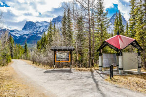
Statistically, four out of five Canadians are a half hour away from one of the world’s longest network of multi-use recreational trails. The Trans Canada Trail (TCT) stretches nearly 24,000 kilometers from coast to coast to coast. Or at least it will soon; the trail’s foundation is pushing for full completion by 2017. Whether they hit their target will largely depend on what it has always depended on: luck, timing, and the dedication of non-profit groups across the country.
“They’re our boots on the ground,” says Jane Murphy, TCT’s National Director of Trail. But it turns out that actually building the trail is the easy part. Before shovels can meet ground, years of pre-planning, engineering, and feasibility studies with license and approvals must take place.
When the trail was initiated in 1992, many sections were already established, such as the Confederation Trail in Prince Edward Island. To build new paths and make the necessary connections, organizers first had to consider typography. For instance, should they build through the Rockies or search for somewhere more accessible? Then they check pocketbooks. If a community lacks the money for development, other options are put forth, such as creating a more cost effective and inexpensive water trail.
Land access is the final determining factor and can be the toughest obstacle to overcome.
“There are some people that react negatively when they hear that trail is going to be developed through potentially their backyard,” says Murphy. “Some people just don’t typically understand trail and the benefits of trail.”
A recent example occurred in Southern Ontario when the municipality purchased an abandoned rail corridor for the explicit purpose of developing the trail. Unhappy landowners, primarily farmers, went to council to voice their opinion. They were successful at first, but TCT was able to turn that decision around. It’s the unknown around trail, according to Murphy, that brings resistance.
And looming above all these steps is a deadline.
“With 2017 around the corner we need to make sure that we find trail projects that can be developed in the very small window of time,” says Murphy.
The TCT has a rough idea of the development schedule for the next three years, but plans are still being made. And even once made, plans often change.
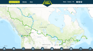
When completed, the trail will connect three endpoints: St. John’s, N.L., Victoria, B.C., and Tuktoyaktuk, N.W.T.
Are you passionate about Canadian geography?
You can support Canadian Geographic in 3 ways:
Travel
The trail started with a vision to link Canada coast to coast to coast. Now fully connected, it’s charting an ambitious course for the future.
Mapping
As Canada's most famous trail celebrates its near completion, Esri Canada president Alex Miller discusses the ambitious trail map that is helping Canadians get outdoors

Kids
Canadian Geographic Education’s series of giant floor maps gives students a colossal dose of cartography and is a powerful teaching tool

Environment
Tracking the country’s extreme weather events to answer the question: are storms getting worse?