
Wildlife
Moose changing ecosystem in Gros Morne
The effect moose have on the Gros Morne National Park ecosystem
- 315 words
- 2 minutes
This article is over 5 years old and may contain outdated information.
Travel
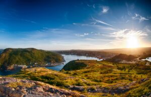
Hitting the backcountry slopes in Newfoundland
“WINDY ENOUGH FOR YA?” I can hardly hear Ed English’s words over the wind whistling past my ears, but on the approach road to the Tablelands region of Newfoundland’s Gros Morne National Park there’s no doubt that it’s windy enough for anyone, anywhere, ever. The 120-kilometre-per-hour gusts that have slammed my car door shut twice in 30 seconds and torn the balaclava from my hands could fry a wind turbine.
But when a Newfoundlander asks you a rhetorical question the proper response isn’t to proffer an answer; instead you wait for the anecdote that’s guaranteed to follow. We retreat to the shelter of English’s aging Honda Civic to gear up, and the backcountry ski guide lets loose. “I came here one morning with my dog, and the wind was really whipping through. Not like today. I opened the door and she jumped out.” English pauses, his bright blue eyes twinkling. “She just blew away. Fifty-pound springer spaniel. Gone. I had to get on my belly and shimmy across the ground to get her back. Then I said to myself ‘That’s it. Looks like I won’t be skiing today.’ ”
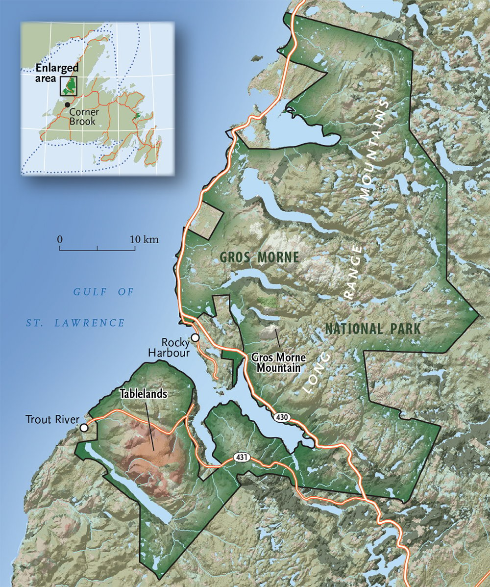
MID-WINTER IN WESTERN NEWFOUNDLAND doesn’t always provide ideal skiing conditions. While the rest of Canada is enjoying the height of the season, persistent gales off the Atlantic have scoured some of the Rock’s finest backcountry slopes. But by spring the wind recedes and the snow softens. English — who has been skiing here since before there was a single chairlift on the island — assures me that some of his finest days of skiing in western Newfoundland have come in April and May, in Gros Morne’s Long Range Mountains. I take him at his word and, staring out at the rocky, seemingly stripped-bare-of-snow Tablelands, wonder why I’m here in mid-March.
Free-heel skis would be useless in such terrain, so we strap our downhill skis on our backs and trudge along the floor of the Trout River valley. Looking north, the scene is typical of the Long Range Mountains, with steep slopes draped in the muted greens of the boreal forest. We, however, are headed south.
English leads me up a barren mountainside unlike anything I’ve ever seen. Littered with countless mustard-coloured rocks the size of footballs and not much else, the Tablelands were once buried deep in the Earth. It’s a landscape that could stand in for Mars.
“The Tablelands don’t look like this because of the elevation,” English says, cheeks glowing crimson from the wind. “The treeline in here is 500 metres, and we’re lower than that now. They look like high alpine terrain because of their geology.” He explains how peridotite, usually found in the Earth’s mantle, was thrust to the surface during a collision of tectonic plates millions of years ago. “These rocks are full of heavy metals, and the land here is basically poisoned. There are some places where soil has blown in and plants have taken root, but otherwise, almost nothing can grow here.”
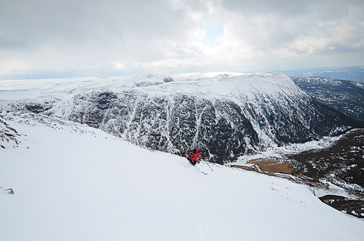
We follow the river drainage higher into the Tablelands and, rounding a bend in its course, see Trout River Bowl peek from between some cliffs. The barren land gives way to a broad, snowy alpine bowl. The sound of howling wind is replaced with a silence broken only by the squeaking of our moulded plastic boots on snow.
English surveys the bowl, assessing the conditions with an expert eye. Born and raised in the area, he’s been guiding in western Newfoundland since 1996, the year he founded Corner Brook–based Linkum Tours, and he knows what trouble looks like. A towering cornice that’s about 10 metres high in places overhangs the highest points of the ridgeline above us. Although there are some more manageable spots from which to drop into the bowl, high winds have undercut the slope, creating potentially dangerous conditions. “That’s an avalanche waiting to happen,” English says, choosing to tack toward a lower (and safer) ridge to the left.
Once we reach the ridge, sunlight, mist and clouds swirl, dappling mountains, fiords and the distant clapboard houses in Corner Brook with bright rays and shadow. We drop into the bowl before the scenery fully reveals itself, ripping off a few turns on some gnarly ice before veering into a bumpy traverse that leads us to a snow jackpot.
Cocooned in the middle of Trout River Bowl is a field of deep and surprisingly dry snow hundreds of metres long. Without hesitation, I point my tips downhill. Every carved turn yields a face full of powder. Only after half a dozen hikes back up — and half a dozen perfect runs through untracked powder — have I had my fill. English spots a single snowy line extending all the way to the valley floor, and we manage to avoid half the walking (and all of the wind) we encountered on the way in.
AFTER THE TABLELANDS, I’m up for a change of pace and some slightly warmer weather. So the next morning, I grab one of English’s kayaks and hit the Humber River.
While much of Canada’s fresh water is still thawing in March, the lower Humber flows freely year-round. Keenly aware of this, dozens of bald eagles have nested on the cliffs that line the river. Floating along on the swift current like the logs it once carried to the local pulp mill, I spend more time gazing at the circling raptors than I do watching the water. But the ride is smooth, and before I know it I’m five kilometres downriver. Bobbing in the Humber Arm fiord and staring at eagles fishing against the backdrop of picturesque Corner Brook, I begin to dread the thought of leaving Newfoundland.
Later, English and I head to the town of Rocky Harbour to seek out expert advice in our continuing quest for powder. We meet with his brother-in-law, Angus Simpson, at Fisherman’s Landing, a homey diner with the sort of sea view that would inflate prices 300 per cent were it located almost anywhere else. A thick-bearded Parks Canada geologist who knows every wrinkle and fold of Gros Morne National Park, Simpson helps us hash out ski routes over a dinner of moose burgers, cod tongues and Quidi Vidi beer.
Simpson tells us how the snow used to come right down to the water in Rocky Harbour, but that in recent years it’s just been melting away at these lower elevations. He suggests we try skiing the gully on Gros Morne Mountain, which should have plenty of snow.
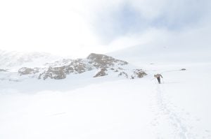
The trail to the peak is a 16-kilometre round trip, so we meet at 7 a.m. to give ourselves plenty of time. In summer, this is one of Newfoundland’s most popular paths, but in winter it sees little use, at least by humans. Moose scat dots the trail, and snowy sections are pocked with their tracks, some a metre or more deep. Despite the mild weather, the trail is firm, the walking easy.
After an hour of tramping through dense woods, the forest opens up. A series of ponds mirror ridges emerging between trees in every direction, with Gros Morne Mountain rising above them all. At 806 metres, it’s not the highest mountain in Newfoundland, but it’s probably the most imposing. At over a billion years old, the Long Range Mountains are among Earth’s oldest, but even rounded by age, much of Gros Morne Mountain is too steep to hold snow. Two long, steep gullies descend from the peak, however, and each cradles the mountain’s snowfall between its high walls.
Strewn with boulders and so wind-scoured in spots that you can barely chip a foothold from the snow, the gully makes you earn your turns. But the view from the summit easily overwhelms any sense of frustration built during the roughly onekilometre climb. On a clear day, it feels like all of Newfoundland is laid out before you.
I savour the scene before dropping in for the descent. Much of the higher terrain is still shaded, and in a few spots it’s virtually bulletproof and barely skiable. Before long though, the gully’s walls recede and a broad tongue of corn snow reaches toward the valley floor. With the sun shining and the snow soft, the descent becomes everything spring skiing is supposed to be.
My thighs are burning and sweat is beading my face, but finally — mercifully — there’s no farther to go. I look back up at the peak. A smiling English points toward the adjacent gully with his pole and asks with a wry smile, “One more?”
“Game on,” I reply, barely noticing the climb I’ve signed up for. After all, the best turns are earned.
Wildlife
The effect moose have on the Gros Morne National Park ecosystem
Travel
Skiing has never really been the sport of the masses, but the rising cost of hitting the slopes combined with the declining expendable income of the middle class has contributed…
Travel
Leslie Anthony shares the best of the big hills
Travel
Immerse yourself in Viking archaeology and Basque whaling history while taking in Newfoundland’s scenic coastline and incredible geology