Environment
Inside the fight to protect the Arctic’s “Water Heart”
How the Sahtuto’ine Dene of Délı̨nę created the Tsá Tué Biosphere Reserve, the world’s first such UNESCO site managed by an Indigenous community
- 1663 words
- 7 minutes
This article is over 5 years old and may contain outdated information.
Exploration
We came to retrace an ancestor’s 1905 map-making expedition of the Peel River watershed. We left with a new-found appreciation of what this ancient land means to the people who live there.


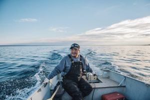
Ernest Vittrekwa hangs over the front of his aluminum boat, elbows deep in the cool, dark waters of the Peel River. It’s late July, fish-smoking season here in the Peel watershed, land of the Tetlit Gwich’in.
The 75-year-old Gwich’in Elder pulls first one, then another, whitefish from his net. He doles out an efficient, practised thwack to each of their heads with a piece of driftwood and throws them into a bucket. He’ll repeat this ritual several times today. Six fish a day is the usual catch. “It’s good living out here,” he says. “It’s good for your health and everything.”
I’m with Vittrekwa at his fish camp just south of the hamlet of Fort McPherson, N.W.T., at the end of a two-week Royal Canadian Geographical Society-funded expedition. With my cousin Terry Camsell and my son, Graham, 17, we’ve been retracing the route taken in 1905 by my great-grandfather and RCGS founder Charles Camsell. At the time, Camsell was working for the Geological Survey of Canada and leading the first formal mapping expedition through the Peel watershed, a pristine 68,000-square-kilometre wilderness area that spans from northwestern Northwest Territories into northeastern Yukon.

Rumour launched Camsell’s expedition, as he explained in his 1954 memoir Son of the North: “A story reached Ottawa … that [in 1904] there had been a mysterious stampede out of Dawson into the country to the east where a new placer gold field was said to have been found … I was instructed to investigate. Placer gold was reported to have been found on a tributary of the Wind River known as Hungry Creek.”
Our trip by canoe and kayak down the Wind and Peel rivers was driven by more concrete news out of Ottawa — the Supreme Court of Canada’s decision in December 2017 to overturn the Yukon Party government’s attempt, five years earlier, to open 70 per cent of the Peel watershed to resource exploration and development. The Yukon government plan came despite the work of an independent commission that had spent three years consulting Indigenous and non-Indigenous communities, and which then issued a report recommending that 20 per cent of the watershed be set aside for exploration and the remaining 80 per cent be protected. The current Liberal government in Yukon fully accepts the Supreme Court decision and is moving forward to implement an 80 per cent conservation plan for the Peel.
The watershed has been the territory of the Gwich’in for centuries, and it was Gwich’in land claims agreements that tipped the case in favour of the area’s protection. We were in the region because of our Charles Camsell connection, but the Supreme Court case had further piqued my interest and that of my cousin — who is Métis and has Gwich’in ancestors — in revisiting the journey Camsell made 113 years ago and seeing how the landscape had changed.
Water from almost the entire Peel watershed flows past Vittrekwa’s fish camp and Fort McPherson. Vittrekwa, who once worked in the oil and gas industry, says he understands what the implications could have been if the Supreme Court decision had gone the other way. “I’ve been out in the oil sands in northern Alberta,” he says. “The country is dead, the timber is dead, because of the contaminated water.”
Vittrekwa’s fish camp is one of many on the Peel. It’s a collection of small wood cabins and smoke huts, set among the spruce and willow forest in the plains north of the Arctic Circle. He and his wife, Alice, 69, raised their four children here, and now their two grandchildren visit regularly.
Standing over a wooden table, Alice Vittrekwa cleans and prepares the fish her husband has caught for smoking. She prefers to burn willow, for the flavour it adds. She mops the blood and guts from the table with a handful of moss. “Gwich’in paper towel,” she says with a smile. “I’m out here because that’s our Gwich’in way of life,” she adds. “I enjoy being out here. With alcohol and drugs in our community and so many negative things happening, being out here listening to nature gives me peace and quiet.”
The Vittrekwas are living a traditional way of life, much as their Gwich’in ancestors did, netting and smoking fish in the summer, and hunting moose and caribou in the winter. The cost of living in the Canadian Arctic is two to three times higher than in Southern Canada, so for the majority of First Nations in this region, like the Vittrekwas, harvesting fish and meat from the land helps offset that expense.
When I show Ernest Vittrekwa my great-grandfather’s 1905 map, he points to the different waterways he has travelled during winter hunting expeditions into the Mackenzie Mountains, casually describing them in a way city dwellers might talk about the route they use to get to work. Camsell may have put the Peel watershed on a map, but for the Gwich’in, it has been imprinted in their psyche for centuries.

Charles Camsell was Métis, the son of a British father who was chief factor for Hudson’s Bay Company in Fort Simpson, N.W.T., and a Métis mother originally from the Red River Settlement in present-day Manitoba. Working for the Geological Survey of Canada, Camsell charted hundreds of thousands of square kilometres of Canada’s North, mostly by canoe, in the first two decades of the last century, before going on to become a deputy minister in the federal government and commissioner of the Northwest Territories.
His 1905 expedition involved canoeing some 4,000 kilometres over a period of nearly four months with a crew of seven, including his brother, Frank Camsell, and the legendary Métis guide, Louis Cardinal. Our expedition is a stripped-down version of that, covering some 600 kilometres in a canoe and kayak through the heart of the region. And while we arrive at the headwaters of the Wind River via a Beaver float plane, Camsell and his team had a much more treacherous journey, hauling their gear for days over a pass in the Mackenzie Mountains to reach Nash Creek, which flows into the Wind. “Not only was Nash Creek swift and shallow but it was sometimes blocked by snowslides from the bordering mountains,” Camsell wrote in his memoir. “Once we had to run our canoes through a snow tunnel, rather than portage over the slide.”
He finally arrived on the Wind River on July 8, and his account makes note of snowslides and even ice sheets on the Wind River. We started our journey on July 17, but the only ice or snow we see at the headwaters is high on the mountain peaks around us.
Camsell described the landscape in his Geological Survey of Canada report: “The valley occupied by the Wind River is broad and U-shaped, timbered in some parts by spruce and poplar, but totally bare in others. In this the Wind River flows in a broad, shallow bed sometimes half a mile wide. Where confined to one channel, the breadth of the stream?… is 100 feet and its water is beautifully clear and blue.”
The water is still dazzling, and even at its deepest points of two to three metres, you can see right to the bottom. The scenery near the headwaters of the Wind River, meanwhile, is just as stunning. The words that pop into my head out of nowhere as we descend the river are, “This is where the world began.” It is a pristine, primordial mountain valley that looks today just as Camsell described it. The only sounds you hear are natural: birds, rushing water and wind through trees. No engines. No hum of traffic. Not even planes passing overhead. Just nature. We don’t see another person for the next two weeks.

For the first half of our trip, we’re paddling out of the top end of the Rocky Mountain chain and dropping into the Arctic plains, past jagged mountain peaks and through wooded valleys. The river is a series of fantastic S-turns and Class One and Class Two rapids — challenging, but not too dangerous.
We camp mostly on gravel shoals or moss-covered islands in the river. The sun is up for 24 hours, so we often leave late and paddle late.
When we arrive at our campsite at the junction with the Little Wind River several days into our trip, we walk up to a ready-made firepit. “You can tell Dene people made this,” my cousin says. “It’s built for comfort.” True enough. Around the firepit are logs raised on sturdy stumps, perfect seats to sit, talk and bask by the fire.
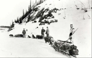
His comment is a reminder that this is the traditional land of the Gwich’in. The Wind valley has been their winter hunting grounds for generations. In past centuries, they’d load up furs and provisions into moose-hide boats in spring and ride the high waters from the snow melt down to the Peel, where they’d spend the summer fishing. The last of these flotillas sailed down the Wind in the 1920s.
We see plenty of wildlife on our journey: eagles, falcons, ducks, geese, Dall sheep on the high, jagged cliffs above the river and, on two occasions, woodland caribou. The caribou are immediately startled when they see us and bolt from the riverbank for cover in the nearby spruce forest. If three people quietly paddling down the river can startle them that much, it makes us wonder, what would a large-scale mining operation do?
We make a special effort to stop at Hungry Creek, the site of the alleged stampede of prospectors that sent Camsell on his expedition in the first place. About 40 kilometres south of the junction with the Peel River, it’s a beautiful spot, with the river curving sharply around the sheer granite cliff face of Mount Deception, a set of rapids pounding against the cliff wall. Peregrine falcons swoop for prey from the nest clinging to the mountainside.
As it turns out, the Hungry Creek stampede of 1904 was most likely just two men known only as Waugh and Warren, who never had luck panning for gold and faced problems getting supplies. In 1910, a Mountie patrol found them near starvation in their cabin. Waugh killed himself the next year. It’s too bad he and Warren didn’t bump into Camsell as he came down the Wind. He could have saved them grief. “Coarse gold is supposed to have been found in the gravels of Hungry Creek?… very little indication placer gold was found on the bars within five miles of its mouth. It appears an unpromising place for the occurrence of gold,” he wrote in his 1905 survey notes, before concluding that “The Wind River does not flow through a markedly mineralized belt of rocks.”

As we approach the Peel River a day later, though, we do find coal. It’s everywhere along the riverbanks. Camsell writes of seeing a large burning seam of it. We don’t, but the region does sit on an estimated 400 million tonnes of coal. The remote location, and low price of the commodity, have left it in the ground. But the Peel region is also rich in iron ore, uranium, oil and natural gas.
Spend a day or so visiting Whitehorse, Yukon’s capital, as I did before our journey began, and you quickly understand the almost mythical hold mining has on the territory. Yukon licence plates feature a prospector panning for gold, the streets are dotted with statues and plaques celebrating the many characters of the Klondike gold rush, including writers such as Robert Service, Jack London and Pierre Berton, who cemented the legends of that era into the minds of millions of readers around the world.
The resource extraction industry is the third largest sector in Yukon, making up 13 per cent of the economy. Growth relies on exploration, which has increasingly seen the industry butt heads with First Nations and environmental groups, both of which want to protect wilderness areas.
That tension is evident outside the headquarters of the Yukon Chamber of Mines in Whitehorse, where a sign reads “$100 reward for information leading to the arrest and conviction of the person or persons causing willful damage to the Yukon Chamber of Mines.”
Inside the chamber’s offices, I meet Jonas Smith, executive director of the Klondike Placer Miners’ Association. Currently the federal Conservative Party candidate for Yukon, he was also deputy chief of staff to former premier Darrell Pasloski, leader of the government that oversaw the attempt to open up the Peel watershed to exploration.
“Absolutely missteps were made,” Smith admits of his government’s plan for the Peel. “Things could have been done better. But I’m a believer that it takes two to tango and this whole situation was blown out of proportion.” Blown out of proportion, Smith believes, by international environmental groups who leapt into the debate with little understanding about the region. “I appreciate that some people may want certain amounts of land set aside for conservation purposes, but no matter how you look at it personally, removing 14 per cent of your land mass from resource development is going to limit you,” he says, noting that he doesn’t see tourism stepping into that hole. “The reality is that the amount of money tourism brings in versus the amount that resource development does are orders of magnitude in difference. Resource development employs everyone from a janitor to people that sell multimillion-dollar pieces of equipment to environmental engineers to truck drivers. Tourism cannot boast that level of economic impact or the number of jobs, particularly higher-paid skilled jobs.”
But James Ross, a former Tetlit Gwich’in Chief who negotiated the land claims agreements in place in this region back in the early 1990s, says he isn’t against resource development. Like many here, he worked in that industry for years. “One of the things the First Nations have been saying for the past 100 years is we are open to development, open to discussions,” he says. “But come to us in our home communities and have that discussion with us, like you would have with your investors.”

Like us, when Camsell reached Fort McPherson in early August 1905, he stayed at a fish camp, one that belonged to a Gwich’in man named Peter Ross (not related to James). They spent an evening together, with Ross recounting legends of the Gwich’in. One of them was an origin story, of when the crow and the beaver joined forces to create land back when the Earth was flooded. That first land is Crow Mountain in Gwich’in country.
“Climb to the top of Old Crow mountain, which lies on the north side of Porcupine River,” Ross told Camsell, “you will find the crow’s magic stick still standing where he made the first land.”
So, this is where the world began.
When we land our canoes at the Vittrekwas’ fish camp, it’s late on a rainy night with a cold wind pounding in from the Beaufort Sea. Despite our being wet and muddy, the Vittrekwas greet us with hot tea and seats by the fire in their cabin. As we leave for our hotel in town, my cousin says, “I’m glad you got to see real northern hospitality.”
The Vittrekwas, like so many we met on this trip, are incredibly welcoming. But they’re also aware of the need to protect the land they love. After 41 years of marriage, the couple have become biologists, of sorts. Twice a week they send samples of the fish they catch to Vancouver to be tested for pathogens such as mercury as part of an environmental research program at Simon Fraser University.
“So far, we’re lucky — the fish is good and we want to keep it that way,” Alice Vittrekwa says as she sits with her husband outside their smokehouse, looking down over the Peel River. “Because if the water is polluted, we can’t fish, and then what are we going to do?”

This story is from the May/June 2019 Issue
Environment
How the Sahtuto’ine Dene of Délı̨nę created the Tsá Tué Biosphere Reserve, the world’s first such UNESCO site managed by an Indigenous community

Exploration
David McGuffin shares insights from his daily log during his summer 2018 expedition retracing a legendary trek on the Yukon’s Peel River

People & Culture
Recalling a memorable Christmas along the trail to the Klondike in the 19th century with an annual reading of Charles Camsell’s Arctic explorations by podcast host David McGuffin
People & Culture
Recalling a memorable Christmas along the trail to the Klondike in the 19th century with an annual reading of Charles Camsell’s Arctic explorations by podcast host David McGuffin