History
2014 Victoria Strait Expedition
This year's search is about much more than underwater archaeology. The Victoria Strait Expedition will contribute to northern science and communities.
- 1205 words
- 5 minutes
This article is over 5 years old and may contain outdated information.
History
Ships, sonar and autonomous underwater vehicles sweep the water as the Victoria Strait beckons

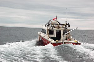
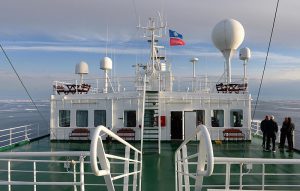
The pieces of the Victoria Strait Expedition began to fall into place over the weekend, and by Monday afternoon the search for the Sir John Franklin’s lost ships, HMS Terror and HMS Erebus, revved up to unprecedented levels, with the Arctic Research Foundation’s Martin Bergmann, One Ocean’s Voyager cruise ship, Parks Canada’s Investigator and the Canadian Coast Guard’s flagship ice breaker, Sir Wilfrid Laurier, all contributing to the search.
Guided through ice-choked Peel Sound by two Canadian Coast Guard icebreakers, Voyager arrived in Queen Maud Gulf on Saturday, and served as the launch platform for the autonomous underwater vehicle (AUV) Arctic Explorer. Operated by Defense Research and Development Canada, Arctic Explorer is the most advanced AUV ever deployed in search of the lost ships.
Arctic Explorer is capable of operating independently for two to three days at a time, and helps open new frontiers in the search. Critical among those areas is the so-called point of abandonment — where Franklin’s crew left the ships in 1848 — in the Victoria Strait. Located off the west coast of King William Island, the strait is fed with ice by the M’Clintock Channel, which itself is fed by the polar ice cap. Ice can be thick there, and has been known to cover the strait for several years on end.
“It’s an area that’s never been searched, despite being a very obvious place to look,” says Ryan Harris, the Parks Canada archeologist who is leading the search for the ships. “There can be a lot of ice there and it’s deep. The area is perfect for an advanced AUV to search.”
The team had planned to deploy Arctic Explorer at the point of abandonment on Aug. 28, but heavy ice has forced a change in plans. Ice coverage in Victoria Strait topped 90 per cent in recent weeks, and for the time being the focus has shifted to the Queen Maud Gulf, where one of the ships is suspected to have drifted.
“The Victoria Strait is expected to clear this year,” Harris says. “It’s just a matter of when. Hopefully it will clear in time for the Voyager to get up there and put Arctic Explorer in the water.”
Meanwhile, the Sir Wilfrid Laurier is serving as a platform from which to search for the ships in the Queen Maud Gulf. Parks Canada’s Investigator, a 10-metre vessel designed for underwater archaeology use, is based on its deck, as are Gannet and Kinglet, two smaller vessels used by the Canadian Hydrographic Service to chart Canadian waters with multi-beam sonar. This type of sonar is not a primary tool for underwater archeologists, but it is a valuable addition to their toolkit.
“The Canadian Hydrographic Service can move more quickly than us and in shallower waters,” Harris says, noting that Parks Canada archeologists are continuing their side-scan sonar search, and will also be deploying their own smaller autonomous underwater vehicle to reach less accessible areas. “Their multi-beam sonar won’t pick up cultural objects in deep water, but it can produce a very clear image in shallow waters, and go places where our side-scan sonar can’t. Their work is helping us fill in the blanks on what we’re doing.”
While side-scan sonar is the ideal tool to scope out shipwrecks, even when it’s working flawlessly archeologists can’t always tell right away if something on the sea floor is actually a shipwreck. “Multi-beam sonar gives a picture of all the relief on the sea floor,” says Thierry Boyer, a Parks Canada archeologist, “and when we cross reference its imagery with what we get from our side-scan sonar, we can tell if something just looks like a shipwreck or actually is one.”
History
This year's search is about much more than underwater archaeology. The Victoria Strait Expedition will contribute to northern science and communities.
History
Arctic historian Ken McGoogan takes an in-depth, contemporary perspective on the legacy of Sir John Franklin, offering a new explanation of the famous Northern mystery
History
First official day of the 2014 search for Sir John Franklin’s lost ships

History
From noble mountains to local elementary schools, the Queen’s reign and the bonds she’s forged with Canadians are reflected across the map of Canada