This article is over 5 years old and may contain outdated information.

Mapping

New Inuit trail map could change the way we look at the North

  • Jun 22, 2014
  • 255 words
  • 2 minutes
Expand Image
Advertisement

It started with trust. It had to. But it was a trust that was gained slowly, over 15 years of cooperation between three university researchers and the various Inuit communities that dot the Canadian Arctic. Only, they’re not dots. As this new interactive online atlas shows, the Inuit have lived in and traveled through vast swathes of the Arctic land, sea and ice. Their historical footprints are the basis for Pan-Inuit Trails (pictured above).

“We’re not outside researchers coming in to exploit the Inuit. We literally and metaphorically give voice to local people,” says atlas co-author Fraser Taylor. He represented Carleton’s Cartographic Research Centre, and worked with the Marine Affairs Program at Halifax’s Dalhousie University and the geography department at Cambridge University to complete the project.

But not only does Pan-Inuit Trails provide a record of Inuit history, as passed down by the elders and 19th century maps, it also adds weight to the Canadian government’s push for Arctic sovereignty and control of the Northwest Passage.

“We show that this is very much Canadian territory, both in land terms and in sea terms,” Taylor says.

So what did the Inuit use these trails for? Many of the routes are seasonal, connecting people to places where animals can be found at particular times of the year. They link neighbour with neighbour, establishing connections that span the North American continent from Greenland to Alaska.

Advertisement

Are you passionate about Canadian geography?

You can support Canadian Geographic in 3 ways:

Related Content

People & Culture

With old traditions and new tech, young Inuit chart their changing landscape

For generations, hunting, and the deep connection to the land it creates, has been a mainstay of Inuit culture. As the coastline changes rapidly—reshaping the marine landscape and jeopardizing the hunt—Inuit youth are charting ways to preserve the hunt, and their identity. 

  • 5346 words
  • 22 minutes

Mapping

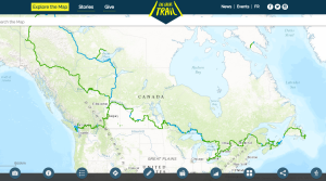
How the Great Trail interactive map is linking communities and changing exploration

As Canada's most famous trail celebrates its near completion, Esri Canada president Alex Miller discusses the ambitious trail map that is helping Canadians get outdoors

  • 1298 words
  • 6 minutes
Heinrich Scherer's 1702 chart of the North Pole

People & Culture

Why the North Pole matters: An important history of challenges and global fascination

In this essay, noted geologist and geophysicist Fred Roots explores the significance of the symbolic point at the top of the world. He submitted it to Canadian Geographic just before his death in October 2016 at age 93.

  • 5167 words
  • 21 minutes

Travel

Trans Canada Trail celebrates 30 years of connecting Canadians

The trail started with a vision to link Canada coast to coast to coast. Now fully connected, it’s charting an ambitious course for the future.

  • 1730 words
  • 7 minutes