Science & Tech
How Canada is preparing for the next big earthquake
The last megathrust earthquake to strike Canada was in 1700, and the clock is ticking. How we’re preparing for the impact.
- 2809 words
- 12 minutes
This article is over 5 years old and may contain outdated information.
Mapping
A recent earthquake in Nunavut has drawn attention to Canada's surprising seismic zones

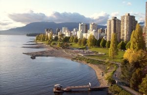
British Columbia is widely known to be Canada’s seismic danger zone, but every so often the shifting Earth reminds us that the rest of the country isn’t immune to the sometimes fickle movements of tectonic plates.
Early Sunday morning, residents of the small Nunavut communities of Resolute, Arctic Bay and Grise Fiord awoke to shaking caused by a magnitude 5.8 quake centred about 85 kilometres southeast of Resolute. No injuries and only light damage were reported, but the quake drew attention to the surprising seismicity of the Canadian High Arctic.
As the map above, created for the June 2015 issue of Canadian Geographic, shows, Baffin Bay was actually the site of one of the strongest earthquakes in Canadian history, which occurred on Nov. 20, 1933. Measuring 7.3 on the Richter scale, it remains the largest known earthquake north of the Arctic Circle.
Here are more of Canada’s biggest quakes, in descending order of magnitude; their epicentres are also marked on the map.
Science & Tech
The last megathrust earthquake to strike Canada was in 1700, and the clock is ticking. How we’re preparing for the impact.

Mapping
Maps have long played a critical role in video games, whether as the main user interface, a reference guide, or both. As games become more sophisticated, so too does the cartography that underpins them.

Environment
British Columbia, Washington State and Oregon sit on a fault line that is capable of producing some of the strongest earthquakes on the planet. A new book reveals it’s not a matter of if, but when the next “Big One” will strike.

Exploration
Natalia Martinez, an RCGS expedition grant recipient, is currently awaiting rescue from Canada's highest mountain