
Wildlife
Our fascination with mammoths
How the legacy of these woolly giants persists in pop culture, storytelling, ecology and even the controversial idea of de-extinction
- 5019 words
- 21 minutes
This article is over 5 years old and may contain outdated information.
Environment
Many of Canada’s 25 watersheds are under threat from pollution, habitat degradation, water overuse and invasive species

Photos of Canada often show the Great Lakes, expanses of wetlands and scenic rivers. The country is described as a water-rich nation, and it is, with seven per cent of the world’s renewable freshwater supply. However, freshwater sources are far from endless.
Many of Canada’s 25 watersheds are under threat from pollution, habitat degradation, water overuse and invasive species. For example, more than half of Canada’s population lives within the Great Lakes watershed, Ottawa basin and St. Lawrence basin, which face multiple threats that degrade water quality and undermine the ability of freshwater ecosystems to keep functioning.
The story of the Great Lakes watershed is not unique in Canada. Ten additional watersheds, from the Winnipeg to the Fraser-Lower Mainland watershed, face high or very high levels of threats. The water quality in more than half of Canada’s 167 sub-watersheds (smaller freshwater systems that drain into a specific watershed) score poor or fair.
In Canada, these watersheds are vast and often inaccessible, making it difficult to monitor the health of these ecosystems. But with the help of a new tool, scientists and community members are collecting data to better understand the state of Canada’s rivers.
Rivers are full of all kinds of small creatures that are highly sensitive to environmental threats. The worms, fly larvae and snails — collectively called macroinvertebrates — that live in the sediment at the bottom of a river (the “benthos”) can serve as biological monitors for water quality. The presence of biological monitor species that are less tolerant of poor water quality is suggestive of a healthy river.
But it can be challenging to sample and identify these macroinvertebrates. Even when there is some data on them, the quality of the data may not be good enough to determine the health of the watershed. To date, 64 per cent of sub-watersheds in Canada lack data on these species.

Gathering data on these species is challenging: Many watersheds are remote and difficult to access, and the cost of flying to them limits the amount of data that can be collected. We partnered with local community groups to collect river samples so that we could understand river health by identifying macroinvertebrates from their DNA.
DNA technologies have revolutionized the amount of data we can generate from a single river sample.
For example, one technique called “environmental DNA metabarcoding,” or eDNA for short, involves taking samples of soil or water and searching for fragments of DNA specific to certain species. This method eliminates the time-consuming process of sorting individual samples and enables us to identify the different species present in a river system.

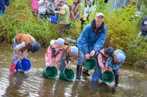
Once you’re at a river, collecting samples is fast and easy — all it takes is three minutes of kicking river sediment into a net to capture the macroinvertebrates that live in the benthos. We taught this technique to people involved in a community-based monitoring network called CABIN to create a new biomonitoring project: STREAM (Sequencing the Rivers for Environmental Assessment and Monitoring).
Since 2019, STREAM scientists have trained more than 100 community members who have gone on to collect almost 1,000 samples across 10 watersheds. We’re close to our goal of 1,500 samples in 15 watersheds in Canada. Yet we’re already beginning to see how the STREAM project is filling in the blanks for freshwater health across Canada.
Not only has the STREAM project provided data on the health of the Great Lakes and Ottawa River watersheds — and the threats to them — it has enabled communities to ask questions about their aquatic ecosystems.
In collaboration with Slocan River Streamkeepers, an environmental stewardship group based in Winlaw, B.C., and Integrated Ecological Research, an environmental consulting service based in Nelson, B.C., STREAM has been able to assess changes in macroinvertebrate communities after the completion of a wetland restoration project. Although this project is ongoing, early results show the wetlands already have a high variety of macroinvertebrates, with 178 species identified. A quarter of these species are indicators of good wetland health, meaning water quality in the area is likely improving.
With Living Lakes Canada and the Ghost Watershed Alliance Society, parts of the Bow River, in Alberta, are now being screened for sludge worms, which can carry the parasite that causes whirling disease, an infection that can wipe out up to 90 per cent of young salmon, trout and whitefish. Loss of these fish has ecological, economic and social consequences in Alberta, where they are important recreational and sustenance fisheries. DNA results from 2019 indicated that the host sludge worms had not spread beyond the known whirling disease zone.

STREAM provides a unique opportunity to bring benefits to both people and the environment. Through using DNA-based technology, it is possible to determine changes in water quality at local, sub-watershed and watershed levels. For continued monitoring of the Bow River for example, the rapid result turnaround provided by STREAM means any indications of sludge worm dispersion can be dealt with by closing angling access to the area to prevent potential spread.
STREAM empowers local communities to lead freshwater research and equips people to address their own environmental questions — and it can easily be applied to other countries as a means to monitor freshwater systems.
Wildlife
How the legacy of these woolly giants persists in pop culture, storytelling, ecology and even the controversial idea of de-extinction

Wildlife
One thing researchers weren't expecting to find: yellow perch cannabalism

People & Culture
An interview with Inuit artist Bart Hanna, whose sculpture of the Inuit sea goddess has been unveiled on Parliament Hill as part of the celebrations marking the 20th anniversary of Nunavut becoming a territory
Environment
Mark Angelo, founder of BC Rivers Day and World Rivers Day, shares insights on his love of rivers, his forthcoming film and what can be done to protect the planet’s waterways