
Mapping
Creative Cartography: Ed Fairburn’s map portraits
Photo: Ed Fairburn's Western Front Cutout series combines ink, military maps and climate charts. (Photos courtesy of Ed Fairburn)
- 553 words
- 3 minutes
This article is over 5 years old and may contain outdated information.
Mapping

This article is part of a series of Q&As with some of the best artists working with maps. Read more Q&As here.
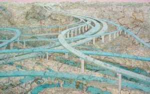
Ross Racine‘s artwork takes us on an aerial trip above bleak, endless, imaginary suburbs. The roads don’t have names or inhabitants, and the maze-like systems seem to stretch on forever. The subject, though, is not too far from reality.
Canadian Geographic: Why do suburbs inspire you?
Ross Racine: I chose suburbia because it offered the most possibilities for creating personal images and for exploring formal and conceptual themes. I came to the subject for aesthetic rather than conceptual reasons, as I think mainly visually. For example, I enjoy spontaneous sketching of abstract linear patterns, resembling road networks.

I was initially attracted to suburbs because of the linear qualities. There is an analogy between their line-based structure and the lines in an artist’s drawing on paper.
I am particularly attracted by aerial photographs of the American West, in desert or semi-arid areas, in suburban or non-urban areas. The West’s dry, flat, barren, open ground seems like a large blank sheet of paper. Also, compared to their eastern counterparts, western suburban developments appear to have been dropped from above onto the land, thus highlighting the disconnect between the human constructions and the natural landscape. For those reasons, I find the Western suburb analogous to a large drawing on paper.

In terms of content, suburbs are to me a particularly relevant subject, symbolic of our global society, as they are the urban constructions that most clearly illustrate population growth, extensive land occupation, and wasteful overconsumption.
Can Geo: What is your subject: the imaginary suburbs you create or the real ones?
RR: Actually, my subject is both the imaginary suburbs in the drawings and the reality of existing suburbia. These two worlds coexist simultaneously in my works.
My drawings are invitations to enter the invented suburbs, to float above them as if they were objects of observation that really exist, although the images often take tremendous liberties with the original models that inspire them.
On the other hand, there is an obvious criticism of actual suburbia in my images, mainly through the exaggeration of certain of its characteristics. But beyond the suburban example, my drawings are a way of thinking about design, the city and society as a whole.

Can Geo: Of all the ways of representing the suburbs you imagine, why did you decide to create maps?
RR: I don’t really consider my images “maps”, but rather aerial views. A map is a stylized abstraction from observable reality, while an aerial view is a view of this observable reality from above, a type of landscape, most often created with a realistic treatment or through photography. For my art, my conceptual models are mainly aerial photography, architectural and urban planning models.

Since childhood I have been fascinated, even obsessed, with both aerial views and maps. I am attracted to the aerial view’s flatness and short shadows, analogous to a relief.
Conceptually, I value the aerial point of view, distant and broad, for its ability to facilitate a synthetic mindset and an attitude of reflection about the world. With the instant availability of this type of imagery on the web, the public has, in the last decade or so, experienced an increased familiarity with the aerial viewpoint, which is quickly becoming as ubiquitous in daily experience as the map. The perpendicular aerial view is one of the principal ways of representing an objet or a scene (the other means being the frontal view) and like the map, its flatness makes it more schematic than the angled view.
Can Geo: What are you hoping people will take away from your art?
RR: I don’t have a single overall concept, as I consider my prints open to different readings, like most images. I would like viewers to be receptive to the various aspects of the art: from its topical considerations about actual suburbia to its science-fictional, hopefully sometimes humorous, exploration of urban organizations, and onto more evocative encounters resting on the viewers own experience of looking and living.
I hope viewers are sensitive to the mood of my images. The mood of an image is something very difficult to put into words, but nevertheless remains a very important aspect of the experience of a work of art. An image is first of all based on form, that’s why it’s an image and not a paragraph of text. An image remains an image before becoming a vehicle for content and a trigger for various interpretations. In this sense, an image is always more than its potential meanings.
Unlike photographs, my drawings are free of the burden of depicting observable reality and lie outside the realm of direct practical application. My suburbs are unconcerned about the consequences of living in them. On the other hand, because of their surreal aspect, the images could be used as brainstorming and mind-expanding aids for planners and other interested viewers. They are often dystopian exaggerations of actual observable situations. In this way they can draw attention to critical aspects of contemporary suburbia. And those of my prints that are rather close to existing conditions can be used as reminders of current environmental predicaments.
Visit Ross Racine’s website to view more images or purchase prints.
Meet Nikki Rosato, an artist who makes map sculptures, and read about David Thomas Smith’s manipulated satellite photos.
Mapping
Photo: Ed Fairburn's Western Front Cutout series combines ink, military maps and climate charts. (Photos courtesy of Ed Fairburn)

Mapping
Maps have long played a critical role in video games, whether as the main user interface, a reference guide, or both. As games become more sophisticated, so too does the cartography that underpins them.
Mapping
This article is part of a series of Q&As with some of the best artists working with maps. Read…
Mapping
We know of Canada’s beauty from the ground; the open lakes, towering trees and jutting rocks that define the wild North.What about from above?We get glimpses…