People & Culture
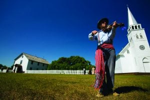
Kahkiihtwaam ee-pee-kiiweehtataahk: Bringing it back home again
The story of how a critically endangered Indigenous language can be saved
- 6310 words
- 26 minutes
This article is over 5 years old and may contain outdated information.
People & Culture

About two months ago, I was sitting in my homely cubicle on intern row at the offices of Canadian Geographic magazine, writing a book review for a novel on American adventurer Ernest Oberholtzer’s travels into the barren lands in 1912.
Oberholtzer and Ojibwe guide Billy Magee paddled and portaged an astonishing 3220 kilometres from Central Manitoba to Hudson Bay and back. That’s like paddling from Toronto to Montréal back and forth, six times; ridiculous. And they did it only in just over four months.
My thoughts turned to a route I had just drawn up for a canoe adventure into the northern bush this summer with five other mates. Paddling from Yellowknife, N.W.T., to Kugluktuk, NU, is somewhere in the vicinity of 1600 kilometres, probably more given the twists and turns of a river. So I did a little bit of investigative research into paddle strokes per minute.
Apparently the average paddler takes approximately 25 strokes per minute. That’s roughly 400 strokes per kilometre, or 1,500 strokes per hour. Do the math, and that’s a lot of paddle strokes. I’m going to go out on a limb here and assume the average paddler doesn’t travel in a canoe heavy laden with gear and supplies over rugged terrain. And that’s exactly what the six of us will be doing, creating educational classroom materials along the way.
Since the inception of the bush plane, getting to the headwaters of the Coppermine has become that much easier. But this crew wanted none of that. For us, arriving to that elusive blue line on the map that carves its way through a river valley for 845 kilometres meant a little blood, sweat and plenty of manly tears. And it also meant paddling back to a time when indigenous peoples survived off the bounty of the land and explorers sought new routes to the orient. It was a time when the bush was a much more formidable opponent, sparing no mercy to those who chose to disrespect her. Improper knowledge of the land meant certain death.
Well, this group is looking for a happy ending, so we decided on a happy medium, something moderately difficult, but not too rigorous, on the hardcore scale. A route where we could pass historic landmarks, all the meanwhile enlightening those who wish to find out more about this land. We think we found it with this route.
Most importantly, there’s an old saying in the bush that goes something along the lines of, “sun’s out, guns out.” And after paddling over 1600 kilometres, I’ll let you interpret the meaning of this ancient phrase.
Are you passionate about Canadian geography?
You can support Canadian Geographic in 3 ways:
People & Culture
The story of how a critically endangered Indigenous language can be saved

Places
In Banff National Park, Alberta, as in protected areas across the country, managers find it difficult to balance the desire of people to experience wilderness with an imperative to conserve it
People & Culture
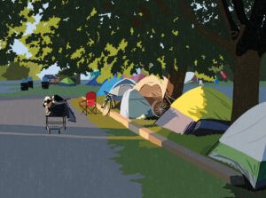
For unhoused residents and those who help them, the pandemic was another wave in a rising tide of challenges
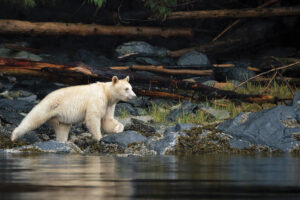
Wildlife
How ‘maas ol, the spirit bear, connects us to the last glacial maximum of the Pacific Northwest