Wildlife
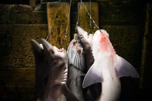
The great green shark hunt
Can British Columbia’s spiny dogfish make the grade as the world’s first “sustainable” shark fishery?
- 3319 words
- 14 minutes
This article is over 5 years old and may contain outdated information.
Wildlife

Imagine finding a mythical black hole into which a major portion of the ocean’s fish disappeared.
That’s akin to what University of British Columbia PhD student Dalal Al-Abdulrazzak did when she discovered 1,900 previously unidentified fishing weirs in the Persian Gulf using Google Earth — the first time a fisheries catch had been estimated from space.
Al-Abdulrazzak, who grew up in Kuwait, estimated that the traps caught roughly 31,000 tonnes of fish in 2005 — almost six times what was reported to the United Nation’s Food and Agriculture Organization.

Why were you initially interested in researching fish catches in the Persian Gulf?
Some countries weren’t making any reference to these traps, and I wondered if it was something we could investigate. It’s a really traditional and common form of fishing, so I found it odd that there was no information in the literature about it.
How did you find out you could see the weirs in satellite images?
It was a complete fluke. I was trying to locate my house in Kuwait with Google Earth and realized you could see the weirs from space. I rushed to my advisor with my laptop to show him and he was really excited.
How surprised were you when you found fish catches were almost six times what was reported?
Fairly surprised, but other studies have shown that official data tends to underestimate catches. To me this was just more evidence that we need better reporting methods. The problem is that weirs are used by small scale fisheries, and are thought to contribute about one per cent to the full amount caught. What I’ve shown is that number is closer to 10 per cent.
Was there reaction from the UNFAO?
They said that the study is unreliable — but we’re certainly not the first to question the quality of their data.
What methods have been used to determine fish catches up to this point?
Normally, some countries do short-term studies, but many of them have no requirement for licencing, so it’s easy to get away with catching more than you’re reporting.
What effect do you think your research will have?
I hope it provides government and policymakers with information to improve our data collection. It’s pretty straightforward, it’s free and, with a little patience, much can be done. We can’t really manage a resource without an adequate picture of what is being removed.
Are you passionate about Canadian geography?
You can support Canadian Geographic in 3 ways:
Wildlife
Can British Columbia’s spiny dogfish make the grade as the world’s first “sustainable” shark fishery?
History
From their beginnings in the late 19th century, salmon hatcheries have gone from cure to band-aid to crutch. Now, we can’t live without manufactured fish.
People & Culture
A moratorium on cod fishing that was supposed to last two years has now lasted 30. What will it take to rebuild cod stocks — and a way of life?
Wildlife
An estimated annual $175-billion business, the illegal trade in wildlife is the world’s fourth-largest criminal enterprise. It stands to radically alter the animal kingdom.