Kids
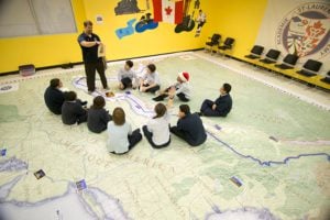
Giant floor maps put students on the map
Canadian Geographic Education’s series of giant floor maps gives students a colossal dose of cartography and is a powerful teaching tool
- 1487 words
- 6 minutes
This article is over 5 years old and may contain outdated information.
Mapping

People follow the plants. Or, at least that’s what it looks like according to this plants hardiness map from by the government of Canada. Perhaps it comes as little surprise that the areas where vegetation thrives happens to coincide with the areas of highest habitation.
This map in particular combines information about a variety of climatic conditions across the entire country to produce a single map. The original was developed in the 1960’s for trees and shubs. What plants grow where you live?
Are you passionate about Canadian geography?
You can support Canadian Geographic in 3 ways:

Kids
Canadian Geographic Education’s series of giant floor maps gives students a colossal dose of cartography and is a powerful teaching tool

Mapping
If you’ve ever had to help make a map, it gives you a whole new appreciation for the art form. As editor of Canadian Geographic, I’ve found myself more…

Mapping
Maps have long played a critical role in video games, whether as the main user interface, a reference guide, or both. As games become more sophisticated, so too does the cartography that underpins them.

People & Culture
Depending on whom you ask, the North’s sentinel species is either on the edge of extinction or an environmental success story. An in-depth look at the complicated, contradictory and controversial science behind the sound bites