
Kids
Giant floor maps put students on the map
Canadian Geographic Education’s series of giant floor maps gives students a colossal dose of cartography and is a powerful teaching tool
- 1487 words
- 6 minutes
This article is over 5 years old and may contain outdated information.
Mapping

For the first time, Canadian Geographic’s giant floor map program is reaching beyond Canada. Wild Migrations is the newest free resource to be released to schools across the country, and it shows the migratory routes of 20 different North American species at risk in stunning detail on our famous 8×11 meter heavy-stock vinyl, with feeding, mating, and resting grounds indicated along the way.

“It helps students to visualize the varied geography of North America and how animals interact with their environment,” says Ellen Curtis, education program manager of The Royal Canadian Geographical Society (publisher of Canadian Geographic).
The data that was used to map the routes comes from a variety of sources. In some cases it’s taken directly from radio collars, while some of the more elusive species’ migration route is more of a good approximation.
“The ocean bathymetry is the best we have done on a giant floor map, and it is also the first map that incorporates Spanish place names,” adds Gilles Gagnier, Chief Operating Officer and Publisher of Canadian Geographic.
The giant floor map was produced through a partnership between CG Education and the Canadian Wildlife Federation.
“Too often in the conservation world there’s a belief or a perception that environmental learning is complementary; it’s nice to learn, it’s nice to have. Our contention is: it’s the best learning. Learning in an experiential way is not a nice-to-have-if-you’ve-got-time, it’s the best way kids learn. And this [giant map] is a great fit for that.”
Can Geo Education has a membership of nearly 13,500 from across Canada. Teachers who are members can request to have this map sent for free to their school. Each floor map comes complete with a trunk of props, activity cards and more to further enhance students’ experience, as well as a teacher guide with ten curriculum-linked activities.
Are you passionate about Canadian geography?
You can support Canadian Geographic in 3 ways:
Kids
Canadian Geographic Education’s series of giant floor maps gives students a colossal dose of cartography and is a powerful teaching tool
People & Culture
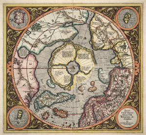
In this essay, noted geologist and geophysicist Fred Roots explores the significance of the symbolic point at the top of the world. He submitted it to Canadian Geographic just before his death in October 2016 at age 93.

Mapping
Maps have long played a critical role in video games, whether as the main user interface, a reference guide, or both. As games become more sophisticated, so too does the cartography that underpins them.
Mapping
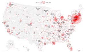
Canadian Geographic cartographer Chris Brackley continues his exploration of how the world is charting the COVID-19 pandemic, this time looking at how artistic choices inform our reactions to different maps