Total percentage of forest killed by mountain pine beetle from 1999 to 2011 (Map: Chris Brackley/Canadian Geographic)
With rain and leaf litter flecking its grey-green surface, alder trees standing sentinel along its banks and a lone vine maple injecting a shot of fiery sunset orange into the muted fall scenery, the stretch of the Fraser River and its surrounding landscape in Fort Langley, B.C., looks like a slightly soggy Thoreau-endorsed picture of natural splendour.
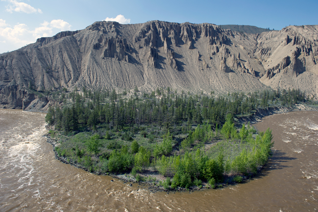
But all is not well. Upstream across the Fraser’s headwaters, climate change has dramatically altered the river by triggering the largest mountain pine beetle outbreak in North America. Cold weather typically kills the beetle larvae, but warmer winters have seen the insect’s numbers spread unchecked across 18.1 million hectares in British Columbia (an area more than five times the size of Vancouver Island), and the outbreak now affects 60 per cent of the river’s 248,035-square-kilometre watershed. The dead forests of lodgepole pine left behind, and the salvage logging there, have made the Fraser basin vulnerable to erosion and flooding, both of which could have serious downstream consequences for wildlife and people.
All of which explains why Steve Marsh is trying to help diagnose the Fraser’s symptoms from the water-slicked dock of the Fort Langley Community Rowing Club, about 60 kilometres east of where the 1,375-kilometre river — British Columbia’s longest — flows into the Pacific Ocean. Every fortnight since 2009, Marsh, a faculty member in the department of geography at the Abbotsford campus of the University of the Fraser Valley, has been supervising his students as they draw murky water from the river, inject the liquid through a filter and into glass bottles and then nestle them snugly into a cooler.
The samples are bound for geochemical analysis on the other side of the continent, at the Global Rivers Observatory, in Woods Hole, Massachusetts, which also keeps tabs on the health of the Mackenzie, Yukon, Amazon, Congo, Yangtze and Ganges rivers, among others. In the Fraser’s case, the results will tell a detailed story of what’s going on across the river’s watershed.
But in a broader sense, the results will also help scientists answer even bigger questions, such as how rivers link the land to the ocean, how they respond to climate change and what role they play in the global carbon cycle. “Our project will give us an idea of what the rivers are composed of today,” says Marsh. “With that picture we have something to judge the future against.”
The world over, rivers feed freshwater, sediment and salts collected from the landscape into our oceans (millennia of river accretion is the reason why the oceans are salty). Each year, the Fraser alone ferries some 113 cubic kilometres of fresh water into the Pacific Ocean (nearly three times the amount of water that Canada’s population uses in the same period) and 17 million tonnes of sediment down to its delta in the Strait of Georgia. “This tie between the land and the ocean is really what drives our research,” says Bernhard Peucker-Ehrenbrink, a geochemist and the Global Rivers Observatory co-director. “It’s quite vital for society’s well-being because if it wasn’t there, the oceans would essentially starve.” Peucker-Ehrenbrink likens the observatory’s work to that of a medical practice. “The hydrologists measure the flow of water, like a cardiologist listening to your heart, and we are the lab technician that works with the blood,” he says. “We want to see how these patients evolve over the next couple of decades, when the world population rises to 10 billion and atmospheric carbon dioxide concentrations continue to rise.”
In many ways, the Fraser River is a model patient. It’s undammed along its main stem, which is a rarity these days (in fact, it’s the longest undammed river in North America south of the Arctic). That’s key because it means everything that’s generated in the watershed — eroded sediment, plant matter, pollution, nutrients, phosphates, nitrates — eventually enters the Fraser and flows all the way down to the Pacific, leaving its mark on the river’s water and ecology. This makes the river a great tool for learning about the landscape that it drains, says Britta Voss, a geochemist with the Global Rivers Observatory who is studying the Fraser. “If we can learn something about what’s happening on the landscape based on what we see in the material carried by the rivers, we might be able to detect changes that are resulting from things like climate change or the pine beetle infestation.”
Voss’s first season on the Fraser was in 2009. She took samples along the entire length of the river and recalls being struck by the extent of the pine beetle devastation: “You see these large swaths of forest, especially around Prince George and farther west, that just look like wastelands.” That amount of dead wood is a fire hazard, but it also has value, which is why the government of British Columbia has given companies permission to log the lifeless forests (the fact that the mountain pine beetle transmits a fungus that stains the tree’s sapwood blue hasn’t deterred buyers, especially in China, where “denim pine” is a hot commodity). Today, the race is on to retrieve the dead wood before it rots. But this aggressive salvage logging creates other problems, similar to those that occur when forests are clear-cut. Normally, trees in a healthy forest intercept rain and provide canopy cover, helping slow the spring melt. But if those trees are dead or removed en masse, snow melt speeds up, runoff increases and the risk of flooding grows. Soil erosion also accelerates and the temperature of the water runoff rises, something that may pose a danger to salmon.
“We have already seen salmon suffer severe mortalities related to high temperatures in the past, and any increase in temperature that may stem from loss of canopy cover through mountain pine beetle infestations cannot be good news,” says John Reynolds, a professor in the department of biological sciences at Simon Fraser University, in Burnaby, B.C. This is particularly true when you consider that the Fraser supports the world’s largest sockeye salmon run on any single river, and its watershed is a nursery for more than half of British Columbia’s salmon production.
So is the mountain pine beetle infestation actually altering the Fraser basin? As more than one study has shown, the answer is yes. In 2010, Markus Schnorbus, a hydrologist with the Pacific Climate Impacts Consortium at the University of Victoria, ran a computer model of water movement in the watershed. “We found that locally the mountain pine beetle and, more particularly, [forest] harvesting, create increased runoff,” he says. That runoff eventually makes its way to waterways such as Baker Creek, a tributary of the Fraser near the town of Quesnel. A 2007 study by the Forest Practices Board, British Columbia’s independent watchdog for forestry practices, found that the combination of mountain pine beetle attack and conventional harvesting increased peak flows on the creek by 60 per cent (peak flow refers to the highest measured flow in a year). After salvage logging removed 80 per cent of the beetle-infected trees, peak flows were 92 per cent higher.
It’s not just the salmon that will feel the effects of increased runoff and higher peak flows, however — people will too, especially as the risk of flooding increases in the watershed, where 6 out of 10 British Columbians now live. “We’re just waiting for the next big flood event,” says Martin Carver, an environmental consultant with Aqua Environmental Associates, who has co-authored government reports on the Fraser’s hydrology. The last major flood of the river was more than 40 years ago, but last summer the lower Fraser neared similar water levels, prompting warnings from at least one forest scientist: “In my mind, there is no doubt the government decision to aggressively salvage logs will increase the flood risk big time,” Younes Alila, an associate professor in the department of forest resources management at the University of British Columbia, told the Vancouver Sun. “We should brace ourselves for the worst.”
Same dock, different season. It’s mid-April and Britta Voss, the Global Rivers Observatory geochemist, is at the Fort Langley Community Rowing Club taking samples from the Fraser during the spring freshet, the thaw that floods the river each year with snowmelt (climate change has resulted in the freshet arriving earlier in the year). It’s rote work — rinse three times, fill the sample bottles, seal them, repeat — but it’s easy for her to see the big picture. “Rather than thinking of rivers as a material delivery system to the ocean,” she says, “more and more people are realizing how the atmosphere and the land are all interacting together.”
By the time the river reaches the lower mainland of British Columbia, where nearly three million people live, it has widened, its flow is lethargic and its water is a muted brown. Once the route for expansion into Western Canada, the Fraser is now an obstacle to be commuted over by car, a murky, backwater alley leading to mountain-crowned Vancouver and the Pacific Ocean. But here, near that terminus, it’s easy to forget that the Fraser’s watershed is sprawling and complex, with multiple processes occurring across the landscape and interacting to influence the health of an entire ecosystem. That’s where the Global Rivers Observatory’s data on the river water comes in. “If you can look at some sort of single indicator that wraps it all together, then that might give you a more holistic perspective than if you say ‘This forest is dying,’ or ‘This fish population is in decline,’” Voss says. “Then you can say ‘This watershed is changing.’”
Scientists such as Voss have good reason to continue monitoring the Fraser and its landscape. A recent study by researchers at the University of Wisconsin-Madison indicated that mountain pine beetles are now infecting whitebark pine, an ecologically and hydrologically valuable species. The B.C. Ministry of Forests, meanwhile, has projected that snowpacks in the Fraser’s watershed will decline by 28 per cent by the 2050s, dramatically altering the way the river flows. By that time, 1.4 million more people are expected to be living in the region.
“All of these things are going to have effects on the river,” Voss says, “so it’s important to monitor it now because the changes will probably be happening within the next few decades.” Behind her the river’s surface is glossy, reflecting the surrounding landscape. In their own way, the water samples lined up on the dock will do the same.
Learn more about Canadian watersheds, including an interactive map and lesson plans for teachers
Appetite for destruction
The mountain pine beetle (pictured top, above) is famous for being the scourge of British Columbia’s forests. Here are a few fast facts on the pint-sized pest with a big reputation for ruin.
- The mountain pine beetle is a native species that behaves like an invasive one.
- Normally, the beetle is an integral part of the forest ecosystem. It lives and breeds in all species of pine trees, which it eventually kills, helping make room for younger trees and plants.
- After boring into a tree, a female beetle releases pheromones to attract mates, and eventually lays 40 to 50 eggs.
- Beetles kill trees in two ways: the larvae eat the layer between the bark and the wood, while a fungus the beetle carries attacks the tree’s sapwood. Both actions cut off the tree’s supply of nutrients.
- The fungus stains the sapwood blue but has no effect on the wood’s strength.
- In winter, the temperature must be below -35 C for several days to kill large portions of the beetle population.
- The woodpecker is a natural predator of the mountain pine beetle, but the birds can’t eat enough to keep the insect’s population down.