This article is over 5 years old and may contain outdated information.

Exploration

Following Shackleton to South Georgia Island

  • Nov 02, 2015
  • 506 words
  • 3 minutes
King penguin colony on the beach at Right Whale Bay Expand Image
Advertisement

Our adventure starts in Stanley, the capital of the Faukland Islands. Following a gruelling 18 hours in the air, we’re transferring to water travel in the Vavilov, the same ship that helped find the Erebus, Sir John Franklin’s lost ship, in Canada’s High Arctic.

From Stanley, we embark on a two-day journey to South Georgia Island, a relentlessly windy speck of land situated at the eastern end of the Drake Passage. We will spend two weeks touring the island, which is approximately 170 kilometers long and between 2 and 40 kilometers wide. Within that space, it boasts mountains, glaciers, fiords and so much wildlife it boggles the mind. Among those who call it home: a million king penguins, 4 million macaroni penguins, a million fur seals, nesting grounds of the wandering albatrosses, elephant seals and the remains of polar explorer Sir Ernest Shackleton.

Expand Image
Light mantled sooty albatross on its nest in Elsehus. (Photo: Rob Stimpson)

Our first landing is King Haakon Bay, the exact spot where Shackleton landed in 1916 after his 16-day epic journey from Elephant Island just north of the Antarctic Continent. Besides a ship landing, we are here to drop off a New Zealand Mountaineering Team who will attempt the same 50 kilometers traverse Shackleton did of South Georgia in 1916.

This is a project sponsored by New Zealand Antarctic Heritage Trust – called “Inspiring Young Explorers.” We leave them on a beach with a 35 knot wind blowing, snow and ice pellets falling at a 45 degree angle. With luck we expect to rendezvous with them three days later at Stromness on the east side of the island, the whaling station Shackleton ended up at 100 years ago.

Expand Image
New Zealand expedition team heading out for their traverse of South Georgia Island. (Photo: Rob Stimpson)

We weigh anchor, head to our next destination, Elsehus, a small cove on the north end of South Georgia. Here, gray headed and light mantled sooty albatross nest on the cliffs overlooking the South Atlantic. Clambering up an icy pathway, we make our way up the slope where the nests are situated. These majestic birds soar along the cliff faces, hardly giving us a glance. Our cameras snap like mad in the hopes of catching these beautiful birds in flight.

Our next stop – Right Whale Bay — is another new location for me. The wind is gusting around 30 knots as we land but that does not deter the king penguins here. A nice mix of eight-month-old chicks and adults squawk endlessly as we land. The landscape is breathtaking: ringed by mountains on one side and the ocean on the other, I am again awed by this endless spectacle of nature in its primordial form.

Rob Stimpson is a Fellow of The Royal Canadian Geographical Society. He is sending dispatches from a One Ocean Expeditions’ Antarctic cruise.

Expand Image
Entrance to King Haakon Bay with Blue eyed shags flying in the distance. (Photo: Rob Stimpson)
Advertisement

Are you passionate about Canadian geography?

You can support Canadian Geographic in 3 ways:

Related Content

People & Culture

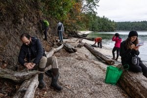
A community’s quest to document every species on their island home

Naming leads to knowing, which leads to understanding. Residents of a small British Columbia island take to the forests and beaches to connect with their nonhuman neighbours 

  • 4643 words
  • 19 minutes
Arctic tern on Machias Seal Island, New Brunswick

Wildlife

Should we kill one bird to save another?

On New Brunswick’s Machias Seal Island, predatory gulls are pushing endangered Arctic tern colonies to the brink, creating a dilemma for wildlife managers

  • 2151 words
  • 9 minutes

Wildlife

Giving Bambi the boot

Our love of deer runs deep. But as their numbers surge and damage mounts, it may be time for a reckoning.

  • 3297 words
  • 14 minutes
Canada's 75 biggest islands

Mapping

Mapping Canada’s 75 biggest islands

Canadian Geographic's cartographer Chris Brackley shares insights into his process in charting the country's largest islands for an exclusive wall map

  • 1341 words
  • 6 minutes