
Travel
Exploring Newfoundland with Adventure Canada
Immerse yourself in Viking archaeology and Basque whaling history while taking in Newfoundland’s scenic coastline and incredible geology
- 1201 words
- 5 minutes
This article is over 5 years old and may contain outdated information.
People & Culture
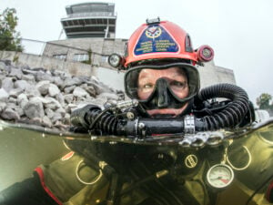
Jill Heinerth is leading a team of divers into the cold February waters to explore and document underwater mines at Newfoundland's Bell Island

This is one of seven expeditions that have received funding from The Royal Canadian Geographical Society in 2016. Watch the CanGeo blog and follow the RCGS on Twitter for updates from all of this year’s exciting expeditions.
Few people know that Bell Island, Newfoundland was directly attacked during the Second World War.
In 1942, German U-boats raided the island in an attempt to disrupt the flow of high-grade iron ore being shuttled from mines on the island to the mainland war effort. Three boats–the SS Saganaga, SS Lord Strathcona, SS Rose Castle, Free French vessel PLM 27–sank along with the island’s loading wharf, killing 70 people.
Now a team of divers is plunging into the cold February waters to explore and document these remarkable war graves. Led by Royal Canadian Geographical Society medalist Jill Heinerth, the group will begin exploring more than 100 km of flooded mine passages beneath Bell Island and the sea floor of Conception Bay where the WWII wrecks reside.
Exploration of these tunnels will reveal a trove of mining relics, pipes, heavy equipment and remarkable graffiti that tells the story of miners who died during their work on Bell Island.
This expedition will document the multi-layered geography of Bell Island from the tough island culture to WWII shipwrecks and abandoned and submerged mines beneath the seafloor. The team hopes to connect Canadians to a remote corner of their country that holds a unique place in cultural history.
Here, Heinerth writes about the first few days of the expedition. Read more of her posts here.
Feb. 15 – First day in the mine
Our first order of business was to take a ferry across to Bell Island and then dig the entrance of the mine out of the snow. Fortunately in Newfoundland, every expedition is equipped with their own personal snow plow. The entire team packed the gear into mine and we set up our rebreather station, medical center and dock area. The infrastructure is well thought out. We are able to use an electric golf cart to get equipment and people down the slope 750 feet to the water. It makes the medical testing and logistics possible in a warm, dry location up top. As soon as we exit the water, we need to rush out of our gear and check in for blood tests, ultrasound and spirometry tests. These tests are repeated every 20 minutes for two hours. At that point we are able to return to gear and camera maintenance.
We had a successful dive mission with 7 divers installing line, working on surveys and documenting the mine. For a first day, we accomplished a lot and we were still laughing at the end of the day.
Feb. 17 – Learning more about the island
We had a very productive morning with efficient deployment of the dive teams. Cas Dobbin and I did a 2-hour dive with the goal of reaching major targets in the 120 foot depth range and taking still photos.
It is incredible having an engineer on the team. Dobbin is able to look at the equipment within the mine and help us all understand how operations might have worked. This becomes mission critical when trying to find new targets for exploration. Tonight he described two theories about how the mine was dewatered from such incredible depths with 100-year-old technology.
Dobbin has also surmised how and where miners were able to tap into steam pipes to run their drills. This knowledge is helping us understand what we are looking at and envision where other infrastructure might be located. It makes it all that more interesting and gave us a refreshed vision of our unfolding map. My conclusion is that there are months if not years of work needed to explore and document this remarkable place.
Soon after diving, we received word that we needed to get off the island early in case of transport issues for the ferry. It is a transitional time right now for the Bell Island Ferry system. In order to circumvent any delays from commuting, we made a team decision to book lodging on Bell Island for the remainder of our dives. Kind owners of the Grand Wabana Inn have offered to take us in so we won’t be facing weather delays.
Tomorrow’s forecast is predicting 100 kph winds and significant rain. Getting off Bell Island would be unlikely. So we will hunker down in the Grand Wabana Inn and see if we experience any of their fabled ghost sightings.
Travel
Immerse yourself in Viking archaeology and Basque whaling history while taking in Newfoundland’s scenic coastline and incredible geology

Travel
Quirpon Island has long been a favourite off-grid getaway for in-the-know travellers. Now, the Quirpon Lighthouse Inn is doubling down on its biggest draws: whales and icebergs.
Wildlife
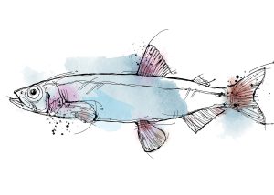
Writer Stephen Smith takes to Newfoundland’s shores in his quest to see the ‘capelin roll’ — the spawning spectacle of a tiny fish with a massive ecological, historical and cultural impact

Exploration
Diver and photographer Jill Heinerth shares a glimpse into the summer phase of The Royal Canadian Geographical Society's Expedition of the Year