
Kids
Giant floor maps put students on the map
Canadian Geographic Education’s series of giant floor maps gives students a colossal dose of cartography and is a powerful teaching tool
- 1487 words
- 6 minutes
This article is over 5 years old and may contain outdated information.
People & Culture

Students in Newfoundland and Labrador will now be able to explore their province’s unique geography and geological history right in their schools thanks to a first-of-its-kind teaching tool unveiled March 2 in Conception Bay South.
A Giant Floor Map of the province joins Canadian Geographic Education’s suite of gymnasium-sized maps and is the first provincial map in the popular collection. One map will tour schools free of charge for teachers, while another will be housed permanently at the Manuels River Hibernia Interpretation Centre for school and public programs, thanks to a significant donation by the Hibernia Management and Development Company Ltd.
The unveiling of the Giant Floor Map of Newfoundland and Labrador happening now at Manuels River! A big thank you HMDC and the @RCGS_SGRC for making this possible! pic.twitter.com/xuOUXfJn3R
— Manuels River (@ManuelsRiver) March 2, 2018
The map was made possible by a crowdfunding campaign led by Newfoundland and Labrador-based Fellows of The Royal Canadian Geographical Society. Elected by their peers, Fellows embody the longstanding values and tenets of the RCGS: the determination to build, the courage to explore, and a steadfast love of Canada. Motivated to share those values with children in their province, the Fellows managed to raise more than $20,000 in less than a year to create the spectacular 11 metre by eight metre map.
A few of the Fellows who worked together to crowdfund for the Newfoundland and Labrador Giant Floor Map unveiled today at @ManuelsRiver. L-R: Latonia Hartery, Dennis Minty, Gordon Slade, Paul Brett, Glenn Blackwood and Allen Clarke. Congrats and THANKS! pic.twitter.com/fB456VUx38
— The RCGS/La SGRC (@RCGS_SGRC) March 2, 2018
The map portrays, in stunning detail, geographical features unique to Newfoundland and Labrador, such as northern Labrador’s Torngat Mountains National Park, with its rugged 3.9-billion-year-old rocky coastline. Through accompanying lesson plans, students from grades K to 12 will also learn about the history and movements of Indigenous Peoples in the province, as well as the story behind the hundreds of abandoned villages that dot the province’s coastline.
The map offers students a concrete way to learn about their province’s geography and to develop a deeper appreciation for its culture and way of life. The Newfoundland and Labrador Fellows hope that their success will inspire Fellows across Canada to fundraise for their own provincial maps.
Amazing to see this product I worked on with my fellow @RCGS_SGRC Fellows come to life so we can learn more about each other and ourselves!
Next step is to adapt the education modules and bring the Giant Floor Map to Labrador! https://t.co/nHovWPXGJ5 pic.twitter.com/1KvFpKCEyM
— Brandon Pardy (@OurLabrador) March 2, 2018
Are you passionate about Canadian geography?
You can support Canadian Geographic in 3 ways:
Kids
Canadian Geographic Education’s series of giant floor maps gives students a colossal dose of cartography and is a powerful teaching tool
Science & Tech
As geotracking technology on our smartphones becomes ever more sophisticated, we’re just beginning to grasps its capabilities (and possible pitfalls)
Travel
Immerse yourself in Viking archaeology and Basque whaling history while taking in Newfoundland’s scenic coastline and incredible geology
People & Culture
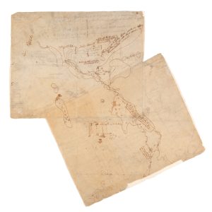
*It means “awake” in Beothuk, the language and people who once called present-day Newfoundland home for about 2,000 years. One young woman, believed to be the last living Beothuk, left a collection of maps and art that help us understand her people’s story.