Kids
Giant floor maps put students on the map
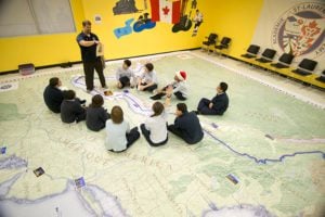
Canadian Geographic Education’s series of giant floor maps gives students a colossal dose of cartography and is a powerful teaching tool
- 1487 words
- 6 minutes
This article is over 5 years old and may contain outdated information.
Kids

They’re as big as half a school gymnasium and weigh more than 45 kilograms, and this fall, they’ll be helping Canadian students learn about their country in engaging new ways. Here’s a quick rundown of Canadian Geographic Education’s three latest giant floor maps.
Parks Canada: Places and Spaces for Everyone
The map highlights Canada’s national parks, historic sites and marine conservation areas. It made its public debut on Canada Day, in Ottawa’s Major’s Hill Park. It will circulate in schools this fall.
Canada’s Energy: Production & Transmission
The map shows the energy facilities and transmission lines across the country. It will also make its debut on Canada Day, but on the West Coast, at Vancouver’s Canada Place. Reservations for the fall school year are now being accepted.
Canadian Boreal Forest Agreement
Outlining the boundaries of the 2010 landmark agreement that’s designed to protect more than 76 million hectares of public forest, this map will begin its one-year journey across the country this fall. It will be available to schools in the 10 cities where a series of public forums on the Boreal Forest Agreement are scheduled to take place.
For more information, or to book these and Canadian Geographic Education’s other giant floor maps, visit education.canadiangeographic.ca.
Are you passionate about Canadian geography?
You can support Canadian Geographic in 3 ways:

Kids
Canadian Geographic Education’s series of giant floor maps gives students a colossal dose of cartography and is a powerful teaching tool

Mapping
Maps have long played a critical role in video games, whether as the main user interface, a reference guide, or both. As games become more sophisticated, so too does the cartography that underpins them.

Mapping
Canadian Geographic cartographer Chris Brackley continues his exploration of how the world is charting the COVID-19 pandemic, this time looking at how artistic choices inform our reactions to different maps

Mapping
This article is part of a series of Q&As with some of the best artists working with maps. Read…