Science & Tech
There’s no map to teaching in a pandemic
Across Canada, teachers are getting creative with their methods and approaches in the classroom to overcome challenges imposed by COVID-19
- 1960 words
- 8 minutes
This article is over 5 years old and may contain outdated information.
Kids


Want to immerse your class in Canada’s geography, but don’t have the space for one of Canadian Geographic Education‘s giant maps? Our new tiled maps might be just the ticket. Simply choose one of the maps below, print it out on a series of letter-sized pages (each of which will show a portion of your desired map) then tape them together to create a large-but-not-unreasonably-large canvas to teach from. Also stay tuned for the soon-to-be released tiled maps of each province and territory!
Arctic Circumpolar tiled map
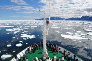
Chances are, you don’t live in the north. Help students gain a new perspective on an area of Canada that they might never have an opportunity to visit in person with the help of this Arctic Circumpolar tiled map. It highlights the North Pole and all oceans and countries surrounding it. Teachers of all grade levels can use this map and the Arctic Imperative project to explore the political, environmental, cultural and geographical issues surrounding Canada’s Arctic.
First World War tiled map
Designed to take students back to a time when Canada was still a dominion, Newfoundland was a separate entity and women couldn’t yet legally vote, ‘A Nation Takes Shape: Canada and the First World War’ is an educational package that will help students understand the impact and influence the First World War had on Canada. With the help of 10 map-associated activities, explore the map to find internment camps and major transportation routes.
Canada tiled map
Want just a standard map of Canada? This map is available to be printed in 40 separate pieces and is the perfect blank slate upon which you can conduct your lesson. Help students get excited and passionate about understanding all that Canada has to offer by following the many activities available for you, including learning about human impact, geography of current events and improving their geographic vocabulary.
Are you passionate about Canadian geography?
You can support Canadian Geographic in 3 ways:
Science & Tech
Across Canada, teachers are getting creative with their methods and approaches in the classroom to overcome challenges imposed by COVID-19

Kids
The Canadian Geographic Challenge, now in its 20th anniversary year, will bring 20 young…
People & Culture
A group of students from around the world who embark on an unforgettable journey of Arctic education wind up discovering something about themselves in the process

Kids
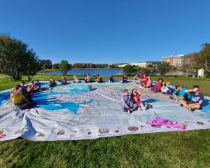
Canadian Geographic Education’s series of giant floor maps gives students a colossal dose of cartography and is a powerful teaching tool